Section 507 Tab A. Guidelines for design review.
I. URBAN DESIGN PRINCIPLES. These principles are based on a shared understanding of the current character and condition of Phoenix as follows:
•Phoenix is a new City reflecting a diversity of architectural styles.
•Phoenix is a large metropolis in a valley of small towns and neighborhoods. Phoenix has been developed largely in small pieces occupying a vast land area. Despite its size, the separation of those pieces remains as a barrier to the goals of community and a higher quality of life. We should seek to diminish these forces of separation in the form of our City by fostering an attitude of neighborliness within our urban fabric. Each development should enhance its neighborhood and relate to the valley as a whole.
•Phoenix is a desert City - our unique environment should be celebrated.
•Phoenix is currently a City with a priority for travel by private vehicles. New development should foster the creation of environments with a priority for pedestrians. The average pedestrian moves at about four mph and views (and uses) the environment in a detailed fashion.
•Phoenix has the opportunity to become one of the great cities of the 21st Century. Our cultural history includes the prehistoric civilization that once inhabited this valley. When we acknowledge this fact, we become one of the few cities in the world to have such a heritage. When we ignore this resource, we become just another large American city.
A. Contextualism. Every development has a relationship to its setting. Positive relationships can be achieved by examining the next largest (and smallest) context of the site. Ignoring the context can often assure poor relationships.
NOTE: Each project should have a context plan.
1. The size, character and setting of proposed protects should relate to their specific contexts and functions of adjacent streets and pedestrian networks. Buildings should be oriented to public rights-of-way as well as additional internal circulation systems.
2. Each project should reflect the broader environmental context of Phoenix as a desert City and respect the value of our scarce resources, the abundance of sunshine and the richness of our natural resources and amenities.
3. The natural environment of our desert context contains critical extremes. The opportunity of a harmonious response exists when these factors are understood and addressed in the design. Those projects which acknowledge this tend to thrive; those which ignore this fact tend to be foolish.
4. New development should incorporate building materials and technology that are compatible with the Southwest setting and that are responsive to the climate of this region.
5. Each project should identify at the outset of its design whether its specific context is an oasis or an arid setting. Deviating from the general character of the site context is generally not appropriate, particularly in the landscape.
B. Amenity/Comfort. Settlements in the desert generally occur in an "oasis" setting which is a respite from the extreme of the larger area context. A development in an arid setting requires design features to aid human comfort. It is important to understand that urban conditions such as paved areas and buildings generating reflected heat create aridity and require mitigating design features which enhance habitability.
1. Promote human comfort by providing shaded areas, courtyards, public and private walkways, colonnades and other areas as site amenities.
2. Create developments for the ease of pedestrians both on and off site.
3. Promote the creation of public and semi-public places at both large and small scales to encourage a sense of community.
4. Recognizing our desert setting, create a sense of place that respects nature and utilizes natural and man-made materials and devices.
5. Protection from the sun and heat is a priority between late April and September, while access to the sun is a priority from October to mid April.
6. Encourage separation of pedestrians and automobiles.
7. Promote night time uses of sites with secure, well lighted amenity zones and programmed activities.
C. Visual Interest. An environment that contains a harmonious balance of various forms and materials can be visually interesting. Too much variety or too much uniformity can lack visual interest. New development should seek to preserve and enhance this basic human need.
1. Incorporate architectural and landscape elements at the pedestrian level.
2. Maintain a human scale by creating variation of the urban form.
3. Recognize the interest created by both the repetition and changes in various project patterns from window openings to paving designs.
4. Promote a diversity of architectural styles.
5. Integrate arts and crafts creatively into the built environment.
6. When a project occurs in a visually rich context, its form, materials, orientation and detailing should incorporate the assets offered by its setting.
7. When a project occurs in a setting devoid of visual interest, it should seek to provide variety of forms and texture.
D. Activity. Environments that provide a variety of choices for people are generally active settings for people to gather. This fosters a sense of community when a visit can serve multiple needs in a setting that provides safety, security, and activity.
1. Encourage mixed-use developments so as to provide increased opportunities for informal and planned activities beyond the typical 9 a.m. to 5 p.m. work hours.
2. Promote design which will increase opportunities for activities both within the project boundaries and between existing adjacent developments and neighborhoods.
3. Where feasible, encourage design of single-usage facilities to accommodate retail and other uses at the pedestrian level to encourage activity and use.
E. Clarity and Convenience. An environment that is easy to understand will usually also be convenient for the people who use it. That is not to say complexity must be avoided. Complexity can offer excitement, but not at the expense of routine accessibility of the general public.
1. Environments should be created that are understandable and help orient the user and the general public.
2. Developments should be convenient to and accessible by persons with physical limitations and disabilities.
3. Developments should derive their basic ordering from the underlying geometry of City streets and the north/south, east/west orientation it implies. This will assist the ready comprehensibility of the City. Individual projects should relate to existing streets and canals, except where creative design establishes a more successful relationship to new streets, pedestrian walkways, or major open spaces.
4. Sites should be planned to respect existing natural and manmade landmarks and to create landmarks for the ease of public recognition.
5. Protect major vistas and panoramas that give special emphasis to open space and mountains.
6. Design project signage and environmental graphics at a scale that provides clarity to the pedestrian as well as the automobile and does not result in visual clutter.
F. Character/Distinctiveness. Every project should strive to enhance the unique character of its neighborhood. Without limiting the creative opportunities for the specific project, the development should help make its neighborhood more distinctive.
1. Each development should contribute to the character identified for each village and the specific character for neighborhoods within each village.
2. Promote neighborhood identity by planning elements that reinforce the landscape and built character of the area.
3. The character and environments should be designed at a human scale as well as within its neighborhood identity.
G. Definition of Space. Streets, parking lots, buildings and landscape are the major elements that define the special qualities of our environment. Organize them to foster a setting supportive to the pedestrian as well as the driver.
1. Relate the size, character and setting of proposed projects to the functions of adjacent streets and pedestrian networks. Buildings should be oriented to the public rights-of-way and close to pedestrian movement.
2. The areas immediately adjacent to buildings should be designed to integrate with surrounding landscape and pedestrian walkways. Shaded courtyards, walkways, cloisters, trellises, colonnades and public art are encouraged for consideration into the design to define space.
3. In an effort to create safe pedestrian walkways on highly traveled public rights-of-way, a buffer area should separate the sidewalk from the street curb.
4. On-street parking should be encouraged in village core business areas to further protect the pedestrian zone from vehicular traffic.
H. Views. City dwellers and visitors alike appreciate being reminded of the beauty of their environment. Protecting views of it assist in fostering appreciation of our environment, as well as allowing the environment to aid in orienting people spatially within Phoenix.
1. Protect major vistas and panoramas that give special emphasis to open space, mountains and special manmade or nature landmarks.
2. Promote the creation of views both from within a project and from the adjacent streets and neighborhoods into the project. Consider the access to views of both the project users and the general public.
3. Create opportunities for incorporating individual projects into the patterns and sequence of views that exist within an area, neighborhood or urban village.
I. Variety/Contrast. Variety of site and building design helps to create interest within an urban area. Coupled with attention to creating environments for human activities, such variety fosters goals of creating identifiable neighborhoods and of encouraging creative development.
1. Promote variety and diversity of building and site design within a context of urban and architectural continuity.
2. Create environments that encourage a number of specific activities fronting the street, court or plaza at ground level to provide variety at a human scale.
J. Scale and Pattern. Ultimately, all developments must relate to the human scale. Patterns help humanize development.
1. A large structure should contain elements which transition to the human scale, particularly near the ground.
2. If a development is larger (or smaller) than its adjacent physical context, the design should provide transitional elements at the perimeter to integrate it with its surroundings.
3. The variation of scale, pattern and texture of building and landscaping elements is encouraged to create a more visually interesting project. The variety should be "readable" at the pedestrian scale as well as from a distance (skyline).
4. The proportion between the height of a building and the width of the street and setback determine the basic urban form. If the intent of the design is urban in character, the height should be greater and the setback less.
5. Building should be designed to reveal or express their primary patterns of use and entry. This will not only assist comprehensibility, but also achieve a desirable variety.
K. Cultural History. Our City is a crossroad for various cultures which can thrive together or be ignored completely. While Phoenix may appear to be a very new City, there are many layers of history upon which this valley has been built. These remnants contribute to our heritage and to the vitality of this City. Honoring this heritage enriches our community. To ignore this decreases the opportunity and significance of the development.
1. Enhance and promote the historical and cultural qualities that are inherent and distinctive to the area.
2. Identify and incorporate as much as possible the particular history of each site. Whenever possible, historically significant buildings and their related landscape setting should be retained and restored, or put to adaptive reuse with respect to their cultural value, and their connection with the City’s heritage.
3. Encourage and develop spaces for activities that promote the local and historic characteristics of the people of Phoenix. These events and activities should take advantage of the Southwest climate and other natural amenities.
4. Building design should be responsive to the existing context - including historical patterns and cultural expectations.
L. Sonoran Preserve. The City Council approved Sonoran Preserve Master Plan provides public amenities that contain large areas of scenic and sensitive lands. The preservation of significant hillsides, addressing the relationship to desert washes and the native vegetation, creates a unique setting for surrounding development, an attractive identity, and an amenity for all Phoenix citizens.
1. Where rezoning occurs adjacent to the Sonoran Preserve, encourage development on the lower slopes below the ten percent slope line, consistent with the general plan, to maintain the preserve as a visual amenity for all citizens and to maintain connectivity between mountains within the same range.
2. Maintain physical access to public preserve lands and a sense of public ownership.
3. Prohibit gated communities adjacent to the Sonoran Preserve that preclude public access to the preserve, except that gated subdivisions will be allowed after assurance that the sixty percent open edge treatment is provided and connectivity in accordance with the Sonoran Preserve Master Trail Plan is maintained.
4. Development design should take advantage of the proximity of the Sonoran Preserve in subdivision layout and site design.
5. Minimize damage in the Sonoran Preserve by providing controlled access points including trails, parking areas and recreation amenities.
6. Encourage commercial uses that compliment and assist in the active or passive enjoyment of the Sonoran Preserve lands near primary and secondary access points to the preserve.
7. Use the desert wash system for storm water management, allowing for the natural function of the floodplain and desert washes where feasible, based on engineering parameters and public safety.
8. Construct bridges and culverts to minimize impacts to washes.
9. The wash system can provide a place for trails, within trail easements above the wash banks, or below the wash banks in approved areas and can provide physical or visual connections to the Sonoran Preserve and wildlife habitat.
10. Use desert vegetation landscaping for low water use, survivability, and to maintain the existing sense of place.
11. Minimize the impact of invasive plant species.
II. CITY-WIDE DESIGN REVIEW GUIDELINES. The design review guidelines indicate specific standards of implementation and are categorized as Requirements (R), Presumptions (P), or Considerations (C).
A. Site Design/Development.
1. Desert Preservation.
1.1. Development should minimize the removal of existing healthy Sonoran Desert vegetation (trees over 4" caliper in diameter) and cacti over 3' in accordance with City Native Plant Preservation Standards (Table 1). If removal is necessary, mature trees and cacti should be salvaged and utilized on site. (P)
Rationale: Sonoran desert vegetation is a slow growing, scarce, valuable resource which provides a unique character and sense of place to this region which should be preserved.
PROTECTED NATIVE PLANTS shall mean cacti, which are three (3) feet, or greater in height and trees which are four (4) inches or greater in caliper of the following species:
|
TREES: |
|
|---|---|
|
Botanical Name |
Common Name |
|
Acacia constricta |
Whitethorn Acacia |
|
Acacia greggii |
Catclaw Acacia |
|
Berberis haematocarpa |
Red Barbery |
|
Canotia holocantha |
Crucifixion Thorn |
|
Celtis pallida |
Hackberry |
|
Cercidium floridum |
Blue Palo Verde |
|
Cercidium microphyllum |
Foothill Palo verde |
|
Chilopsis lineraris |
Desert Willow |
|
Juniperus species |
Juniper |
|
Olneya tesota |
Ironwood |
|
Populus fremontii |
Cottonwood |
|
Prosopis species |
Mesquite |
|
Quercus species |
Scrib Oak |
|
Rhus ovata |
Sugar Sumac |
|
Vauquelinea Californica |
Arizona Rosewood |
|
CACTI: |
|
|
Botanical Name |
Common Name |
|
Carnegiea gigantea |
Saguaro |
|
Ferocactus species |
Barrel |
|
Fouquieria splendens |
Ocotillo |
|
Penicereus greggii |
Night-Blooming Cereus |
1.2. Natural washes and vegetation should be maintained in a natural state to avoid impeding drainage flows to the extent practicable for public safety and preservation of the natural ecology. (P)
Rationale: Natural wash corridors and associated vegetation should be preserved as open space amenities and wildlife habitat corridors.
1.3. Where appropriate, the landscape plan should reflect the establishment of an on-site wash (arroyo) system for surface drainage. (C)
Rationale: On-site wash systems can prove to be more economical as well as being more appropriate for a desert environment.
2. Grading/Drainage.
2.1. Where they exist in their natural state, significant washes which have one or more of the following characteristics:
- Flows greater than 250 cfs. for the 100 year storm.
- Average widths greater than 50 feet.
- Depths greater than two (2) feet.
- Wash connectivity to established watersheds (in contrast to isolated wash segments) and/or
- Significant vegetation or riparian habitats should be preserved. (P)
Rationale: Natural washes can provide a significant landscape open space amenity and ecological infrastructure.
2.2. Surface, site drainage and retention should be designed to avoid hard lined channels. (P)
Rationale: A more natural approach to drainage and retention can reduce the amount of required grading and result in a quality open space amenity for the development.
2.3. Surface site drainage and retention should be integrated with the overall landscape design. (P)
Rationale: Integrating drainage with the landscape design can provide for efficient use of water.
2.4. Retention areas should be integrated into usable open space. (P)
Rationale: More efficient use of land can be made if it serves multiple purposes.
2.5. Required landscape setbacks adjacent to perimeter streets may utilize the required setback for retention provided:
- A maximum 50% of the required landscape setback is devoted to retention.
- The maximum depth of retention within 20 feet of right-of-way is 24-inches.
- Side slopes are a maximum 4:1 (P)
Rationale: The primary purpose of landscaped setbacks on perimeter streets is to improve the image of the public streetscape. Retention should not have a detrimental impact on the pedestrian environment or aesthetic quality of the public streetscape.
2.6. Sites shall be designed to minimize erosion. Steep slopes shall be stabilized with vegetation, rock or other measures. (R)
Rationale: Slopes require means of stabilization unless composed of solid rock or material determined as stable by a geotechnical report.
2.7. Grading plans in non-hillside areas adjacent to residential development should be designed with grades that are lower than or closely match existing grades to mitigate potential impacts on residential privacy. (P)
Rationale: Development with substantially higher grades adversely impacts the privacy of adjacent residential land use, creates barriers and may disrupt drainage patterns.
2.8. Within areas identified as permanent undisturbed open space, no grading or other disturbance shall occur except grading for trails, roadways, utility easements, and fire protection. Restoration of the disturbed area is mandatory and shall follow plans reviewed and approved by the City. (R)
Rationale: Disturbance should be kept to the minimum necessary in areas designated as undisturbed open space.
3. Landscape Architecture.
3.1. Plant Materials.
3.1.1. Development should minimize the removal of existing, non-native healthy plants (trees 4" caliper in diameter) or greater) and cacti (6' high or greater). If removal is necessary, mature trees should be salvaged and utilized on site. (P)
Rationale: Healthy non-native plant material contributes to the historical context and neighborhood identity of an area and is a resource that provides shade and screening which would take years to replace.
3.1.2. At installation, the landscape palette should contain a mixed maturity consisting of 60% of trees with 2-inch minimum caliper and 40% with minimum 1-inch caliper in accordance with Arizona Nursery Association Standards. (P)
Rationale: Mixing maturities creates a more mature looking landscape at installation and promotes greater plant survival.
3.1.3. Low water use plants that reflect and enhance the image of the Sonoran Desert should be used. (P)
Rationale: Water conservation and community image should be important criteria for plant material selection.
3.1.4. A gradual transition of landscape material should be provided where different oasis and arid landscape themes are proposed among adjacent uses. (P)
Rationale: A gradual or consistent landscape treatment among adjacent uses serves to unify the urban fabric.
3.1.5. Any proposed landscape treatment should be compatible with and relate to any established distinctive character in the surrounding context area. (P)
Rationale: Landscape treatment that reflects the distinctive character of the surrounding area can help to create a sense of place and enhance the character of the community.
3.1.6. Street tree improvements shall be made in accordance with adopted streetscape designs for each street or as approved by Planning and Development Department staff. (R)
Rationale: Street trees provide another form of shading and produce a more attractive environment.
3.1.7. Landscape should relate to and reinforce any established identifiable streetscape. (P)
Rationale: Consistent landscaping enhances the existing character of an area and aids in the creation of a sense of place.
3.1.8. Areas proposed for revegetation should be planted on maximum 4:1 slopes. A 3:1 slope for revegetation may be considered if additional natural features and/or vegetation can be preserved. (P)
Rationale: Sites should be designed to minimize erosion, steep slopes, should be stabilized with vegetation, rock or other measures.
3.1.9. Coordinate site utility elements such as overhead power lines, transformers, meter boxes, backflow preventers, and fire protection devices, with landscape design to effectively diminish the impact of such elements on the site character. (P)
Rationale: Coordinating the landscape design with placement of utility elements helps to mitigate their impact and reduce the potential for conflicts as the landscaping matures.
3.1.10. Trees should be located adjacent to public and private walkways, and multi-use trails and paths, to provide a minimum of 50 percent shade and a minimum canopy clearance of six feet eight inches. (P)
Rationale: Shaded clear walkways are necessary for pedestrian health, safety, and welfare.
3.1.11. Pedestrian safety and comfort should be considered when selecting trees and plant material. (P)
Rationale: Trees or other plant materials which drop fruit, pods or nuts, shed bark, or are prone to drop branches can create a danger to pedestrian safety.
3.1.12. Landscape plant material selection and placement along perimeter walls should function to discourage graffiti. (P)
Rationale: When the surface area of a wall is decreased, the opportunity for graffiti is also reduced.
3.1.13. No more than 50% of the landscaped area at maturity or 10% of the net lot area, whichever is less, should be planted in turf or high water use plants. Functional turf areas such as in parks, schools, multiple-family and single-family common areas, individual single-family lot, and golf courses are exempt. (P)
Rationale: The Sonoran Desert environment of Phoenix requires a careful balance of the amount of landscaping and the minimization of water consumption. Landscaping should be used to cool the environment, shade buildings, and improve air quality; high water use landscaping such as turf grass should be limited to areas where they are required for the function of the area.
3.1.14. A minimum 50% of the landscaped area at maturity (excluding hardscape areas) should be treated with living vegetation including groundcover, shrubs and trees, as well as inorganic material and an automatic irrigation system. (P)
Rationale: An adequate covering of living vegetation helps to mitigate the "heat island" effect and is consistent with the Sonoran Desert composition of scattered plant massings.
3.1.15. If allowed by specific provisions of the Zoning Ordinance, the placement of recycling containers in a required landscape setback or required landscaped island should not result in the elimination of any required trees. (P)
3.1.16. Plant materials should be selected for appropriate mature size, space needs, location, and required use for their ultimate location on the site. (P)
Rationale: All plants are not suitable for all locations. Consideration should be given for size at maturity, reason for choice (e.g., shade provision or screening/buffering), maintenance requirements, and long-term viability. Low maintenance plants which have a proven track record of survivability in the urban desert environment should be installed whenever possible.
3.2. Maintenance of Landscape Areas.
3.2.1. Native Sonoran Desert vegetation should not be pruned or removed from areas identified on approved plans as permanent undisturbed open space unless demonstrated to the City that a health, safety or welfare issue exists. This includes removal of dead trees or cacti. (P)
Rationale: Sonoran Desert wildlife is dependent on the habitat created by the natural environment. Dead trees, fallen saguaros and low growth on trees provide cover for a variety of native wildlife.
3.2.2. Landscape treatment must be used for the entire site exclusive of building(s) and pavement for vehicular use. (R)
Rationale: Development should project an image that the entire site has been considered and appropriately treated in the design of the development.
3.2.3. A permanent automatic irrigation system should be installed to water all trees, cacti, and plants installed in accordance with the approved landscape plans or other development review documents to minimize maintenance and water consumption, and to maximize plant health, survivability, and viability, unless otherwise approved by the Planning and Development Department. (P)
Rationale: Different types and species of plants require different amounts of supplemental water based on varying microclimates created by the urban environment to achieve a healthy, viable, long-term survivability rate. An efficient, appropriate irrigation system will support long-term plant health by applying the right amount of supplemental water for optimum plant health and growth and reduce maintenance costs.
3.2.4. Phased developments shall indicate a mechanism for dust, weed, and debris control on undeveloped portions of the site. (R)
Rationale: Disturbed portions of sites which are undeveloped often become unsightly and hazardous due to lack of proper maintenance.
3.3. Hardscape.
3.3.1. Commercial pads and freestanding commercial buildings less than 5,000 square feet should contain usable hardscape for pedestrian circulation and foundation planting to create an attractive visual identity. (P)
Rationale: Commercial pads should be attractively landscaped and functional for ease of pedestrian use.
3.3.2. Pavement materials along pedestrian routes and gathering areas should be chosen to minimize reflected light and glare. (P)
Rationale: Pedestrian routes and gathering areas should be designed with appropriate hardscape materials to enhance the pedestrian experience.
3.3.3. Consider indigenous and alternative paving materials which permit the infiltration of water, yet still provide accessibility to the physically disabled. (C)
Rationale: Infiltration of water reduces runoff.
3.4. Art/Water Elements.
3.4.1. Water features, including fountains, should be sited to allow significant environmental enhancement primarily to on-site and incidentally to off-site users and to minimize water consumption. (P)
Rationale: Water features can provide relief from the extreme desert temperatures, but should be used sparingly with every attempt made to limit the amount of water used. For a City in the Sonoran Desert, Phoenix should project an image of using its limited water resources as efficiently as possible for the benefit of its citizens.
3.4.2. If there is public art, it should be integrated into the overall design of a project. (P)
Rationale: Public art creates a greater impact if integrated into the overall design of the site.
4. Open Space/Amenities.
4.1. Improved open spaces, plazas and courtyards should be shaded a minimum 50 percent and functional in terms of area, dimensions, location and amenities to promote safe human interaction. (P)
Rationale: Shaded pedestrian amenities help to encourage the use of public spaces. With respect to open space, bigger is not necessarily better. A series of small areas, each provided with amenities may foster more human interrelationship than a large monolithic space.
4.2. Usable public space should incorporate a minimum of 50 percent shading through the use of trees or structures that provide shading, or a combination of the two unless otherwise prohibited by site visibility triangles or other technical constraints. (P)
Rationale: Shade is necessary for people to use and enjoy public areas during large portions of the year in Phoenix for their health, safety, and welfare.
4.3. If a developer builds a public park, dedicated to the City, the public park shall be constructed as adopted by the City Council in accordance with the Parks and Recreation Department’s approved standards. (R)
Rationale: Public parks built by developers shall meet the same standard used by the Parks and Recreation Department. A Citywide standard insures service, quality, and equity throughout community.
5. Trails/Paths.
5.1. Public Multi-Use Trails (MUTs) shall be located outside retention areas and wash bottoms unless approved by the Parks and Recreation Department. (R)
Rationale: The public trail system is designed for use by a variety of users. Trails outside of washes and retention are accessible by equestrians, bicyclist, joggers, and the physically challenged. Maintenance is also important. The decomposed granite that comprises the MUT can not be maintained in washes or retention areas that are subject to periodic flooding.
5.2. Public MUTs may be located in public rights-of-ways, landscape setbacks or private properties with an appropriate public trail easement. (P)
Rationale: Placing trails within public rights-of-way or easements insures public andmaintenance crews access.
5.3. Vehicular access (not exceeding 1/2 of a mile) from public collector and arterial streets to off-street parking shall be provided to all designated City primary or secondary trailheads. (R)
Rationale: The Mountain Preserve and associated trails are public amenities. Providing vehicular access to trailheads via public collectors and arterial streets will ensure visual and physical access to open space and minimize potential neighborhood conflicts.
5.4. Vehicular access with on street parking should be provided to all designated City neighborhood trailheads. (P)
Rationale: City neighborhood trails need to be accessible to the public without creating encroachment on private property.
6. Parking/Circulation.
6.1. Surface Parking Design.
6.1.1. Five percent of the surface parking lot, exclusive of perimeter landscaping and all setbacks, must be landscaped. Landscaping shall be dispersed throughout the parking area. (R)
Rationale: To be of greatest benefit to all users of parking lots, landscaping should be dispersed throughout the parking area.
6.1.2. Landscape planters for trees in parking lots shall be a minimum of 5 feet wide (inside dimension). (R)
Rationale: This Landscape planters of sufficient size increase shading and provide enhance survivability for larger trees.
6.1.3. Parking areas should be buffered from adjacent residential properties and screened from streets so that cars are not visible below the average height of the headlights. (P)
Rationale: Objectionable uses should always be screened
6.1.4. Access drives, internal circulation drives, parking areas, and pedestrian walkways shall be designed to provide safety and convenience for both motorists and pedestrians and to insure access for the physically disabled. (R)
Rationale: Enhancing safety and convenience improves the function of a parking area.
6.1.5. For office and retail commercial projects, every parking space should be no greater than 150 feet from a sidewalk leading to the building or from a building entrance, and unshaded segments of walkway should not exceed 15 feet except at driveway crossings. (P)
Rationale: Accessibility and shade enhances comfort and safety for pedestrians and parking lots.
6.1.6. With the exception of safety considerations, the location of driveway curb cuts for parking lots or driveways should not cause the removal of mature landscaping. (P)
Rationale: Saving mature landscaping enhances street character and neighborhood identity.
6.1.7. Surface parking design should utilize shared access drives with adjacent, similarly zoned properties. (P)
Rationale: The number of curb cuts should be minimized and pedestrian access enhanced.
6.1.8. Freestanding surface parking lots or parking lots in residential zoning districts adjacent to residential property should continue the existing setback along common street frontage. (P)
Rationale: Surface parking lots should be compatible and blend with the surrounding residential environment.
6.1.9. Excessive asphalt/hardscape not needed for adequate vehicular maneuvering or parking, staging or material storage should be minimized. (P)
Rationale: Excessive paving used as an alternative to avoid landscape treatment contributes to the "heat island" effect and is not desirable in appearance. Alternative surface treatments should be provided which minimize heat absorption.
6.2. Parking Structure Design.
6.2.1. A parking structure within one hundred-fifty (150) feet of an existing residential use or zoning district shall be entirely enclosed on the side or sides adjacent to the residential district, with the exception of the ground floor. The enclosure shall wrap around the adjacent corners a distance of thirty (30) feet. (R)
Rationale: A solid enclosure will minimize noise, light, and glare and reduce negative impact to residential uses.
6.2.2. A parking structure located more than one hundred-fifty (150) feet away from an existing residential use or zoning district shall be screened a minimum of four (4) feet in height where the sides of the structure are open. (R)
Rationale: Screening of parking prevents light and glare from adjacent uses.
6.2.3. The parking structure exterior should be finished with architectural embellishments and detailing that will create visual interest for adjoining properties. (P)
Rationale: Architectural enhancements on multi-story parking structures will reduce the impact on adjacent properties.
6.2.4. Lighting within the parking structure should provide safety and security and be integrated into the architectural character both in terms of illumination and fixtures. (P)
Rationale: Lighting must provide safety but not be offensive to off-site uses.
6.2.5. Rooftop lighting shall be setback a minimum of twenty-five (25) feet from the perimeter of the rooftop parking structure and shall be a maximum of twelve (12) feet in height. (R)
Rationale: The direct source of light should not be visible from lower levels or adjacent uses.
6.2.6. Staging areas should be designed to accommodate the required queuing within the structures and not on the street. (P)
Rationale: Staging must not interfere with street movement or pedestrian circulation.
6.2.7. Appropriate visibility triangles and pedestrian crossing at exits and entrances should be provided in all parking structures. (P)
Rationale: Parking ingress and egress should not interfere with street movement or pedestrian circulation.
6.2.8. Parking structures which are located adjacent to street frontages and/or sidewalks should incorporate street level occupied space and/or pedestrian arcades along those sides adjacent to these pedestrian circulation areas. (P)
Rationale: Pedestrian amenities create a more active street which adds visual interest as well as enhancing the security of the area.
6.2.9. The parking structure should be integrated with the form and materials of the site structures or the scale, form, color and materials of the adjacent uses. (P)
Rationale: These features will assure efficiency and minimize the disruptive impact to the surrounding uses.
6.2.10. There should be a convenient, clear, safe and efficient internal circulation system within the parking structure for both vehicular and pedestrian traffic including appropriate signage and placement of pedestrian circulation cores (elevators and stairs). (P)
Rationale: Parking structures should provide clarity, safety and be convenient for the user.
6.2.11. Consider the use of landscaping at all levels of the parking structure. (C)
Rationale: Appropriate landscaping at all levels of the structure may substantially enhance the structure design.
6.3. Access/Circulation.
6.3.1. Nonresidential uses should not be permitted to access local or collector streets if adequate access is available to arterial streets. (P)
Rationale: Nonresidential traffic on local streets should be minimized and directed out of neighborhoods.
6.3.2. The site plan should clearly express the separation between pedestrian and vehicular traffic. (P)
Rationale: Clearly separated pedestrian walkways promote pedestrian safety.
6.3.3. Development adjacent to existing or proposed City of Phoenix park sites (neighborhood, community and/or district) should be developed with perimeter streets bounding the park site and/or municipal golf course. Potential exceptions to the perimeter streets presumption might include parks next to Schools, significant public open spaces or natural features. Exceptions to this presumption must be approved by the Parks, Planning, Street Transportation and Planning and Development Departments.
Rationale: High visibility of park open space will enhance the public’s health, safety and welfare. This is especially important in residential land uses; however, non-residential land uses should also be designed accordingly.
7. Walls/Fencing.
7.1. Walls adjacent to arterial and collector streets should have a finished appearance. Untextured, unfinished block and reinforced, mortar-free concrete walls should be avoided. (P)
7.2. Wall lengths exceeding 50 feet adjacent to arterial and collector streets should be articulated or contain substantial landscaping to break the continuous wall surface and create varying shading patterns. (P)
Rationale (7.1-7.2): Perimeter wall treatment should provide decorative elements for visual interest and contribute an enhanced image to the surrounding community. Finished wall treatments should include decorative elements, variation in wall materials, and textured or stucco surfaces compatible with primary structures.
7.3. Subject to the provisions of Section 703.C, temporary fencing must be removed or replaced with permanent fencing within one year of installation, in compliance with Section 703.A, unless extended pursuant to Section 703.C. (R)
Rationale: Temporary fencing does not have the same durability in construction or installation as permanent fencing, and deteriorates more rapidly. This creates a negative aesthetic and image impact when viewed from the street.
8. Site Lighting.
8.1. All on-site lighting is to be shielded to prevent direct visibility of the light source from adjacent property. (P)
8.2. Lighting should be shielded with cut-off fixtures and deflectors to direct light downward and limit on-site lighting levels to a maximum of one (1) foot candle at the property line. (P)
Rationale (8.1-8.2): Lighting should not have an adverse impact on adjacent uses.
8.3. Parking lot and security lighting shall not exceed a maximum of fifteen (15) feet in height including lamp, pole, and base within one hundred fifty (150) feet of a residential district. (R)
8.4. Parking lot and security lighting should not exceed a maximum of twenty-five (25) feet in height adjacent to nonresidential districts.(P)
Rationale (8.3-8.4): The height of light standards at the perimeter of the site should respect the adjacent property.
8.5. Service areas and other screened areas should have proper security lighting. (C)
Rationale: Well lighted areas discourage criminals from loitering and endangering passing pedestrians.
8.6. Lighting fixtures and illumination should be of similar design and character as the project’s building components. (P)
Rationale: Compatible lighting fixtures and other appurtenances help to reinforce the design theme or a project.
8.7. Site lighting should be provided to ensure personal safety at building entrance/exits, and in public assembly and parking areas. (P)
Rationale: Site lighting should provide pedestrians with a sense of security on site.
8.8. Recommended lighting levels and uniformity ratios established by the Illumination Engineering Society of North America (IESNA), as may be modified by the City of Phoenix, should be incorporated in lighting design for on-site non-residential and multi-family development. (P)
Rationale: Lighting should be designed in conformance with nationally accepted standards to provide:
- minimum standards for adequate lighting and safety
- maximum standard to minimize glare and lighting trespass on adjacent uses.
8.9. Illuminative gases, LED lights and fiber optics should not be placed on structures which are adjacent to or across an alley from adjacent residential property. (P)
Rationale: Visible neon/fiber optics represents a commercial intrusion into adjoining residential character.
9. Hillside Development Guidelines.
9.1. Panhandle lots may be considered in hillside areas when they promote the following:
•Preserve significant natural features such as washes, rock outcroppings, and natural vegetation.
•Minimize excessive grading, cut and fills.
•Provide reasonable development opportunities by providing access to buildable portions of steep lots and parcels. (P)
Rationale: Preservation of the natural features and vegetation in hillside areas warrants the utilization of unusual lot configurations.
9.2. A minimum of five feet beyond a building wall or permanent fence should be considered as disturbed area and contribute to hillside grading area calculations unless it can be demonstrated that the wall can be constructed from one side. (P)
Rationale: Establishing a standard that must be attributed to the hillside grading area calculation standardizes the amount of land that would be considered disturbed during the construction phase.
9.3. Driveways in hillside areas should provide safe access while minimizing grading, visible cut/fills and retaining walls. Generally driveways in hillside areas should not exceed 12 feet in width. Additional width may be considered for curves, short driveway lengths, shared access, or joint vehicular/pedestrian access. (P)
Rationale: Establishing maximum grading standards aids in reducing the amount of visual scarring and soil erosion possible from hillside development.
9.4. Disturbed hillside areas should be revegetated with irrigation to prevent erosion and establish plant material of similar type, size, coloration and amount as the context area when mature. (P)
Rationale: Providing irrigation to revegetated soils ensures the establishment of plant materials which prevents erosion and minimizes the visual impact of hillside development.
9.5. The grading of a hillside lot should minimize visible cut and fill to encourage gradual topographical transitions that blend with the natural grade and reduces visual scarring. (P)
Rationale: Minimizing grading and topographical alterations help to preserve the hillside terrain.
9.6. Buildings in hillside areas should be sensitive to and blend with the site through the use of techniques which consider appropriate proportion and scale to minimize the size, massing, bulk and height of visible portions of the structure. (P)
Rationale: Buildings need to be designed to minimize the visual impact they have on hillside areas.
9.7. Exterior building, roofing, fencing colors, materials, and retaining walls that are visible from adjacent property or adjacent streets should convey color, form, textures, and material that blend with natural conditions within the context area. (P)
Rationale: Buildings should be designed to enhance the hillside environment and to not detract from the scenic landscape.
9.8. Hillside development shall preserve ridgeline views and visible significant natural features such as mountain peaks. (R)
Rationale: Ridgelines, peaks and significant rock outcroppings are natural features that provide visual amenities and aid in preserving the ecological infrastructure.
B. Building Design/Construction.
1. Placement/Orientation.
1.1. Building additions and alterations should not eliminate an existing developed pedestrian path or public area. (P)
Rationale: Existing developed pedestrian paths should be respected.
1.2. The proposed building orientation should respect the orientation of surrounding buildings and surrounding streets by maintaining continuity of pedestrian routes and promoting opportunities for pedestrian interaction at the street level. (P)
Rationale: Placement of the building in relation to the surrounding elements is as important as the building design. Site design should encourage the continuity of pedestrian movement and enhance pedestrian interaction at the street level.
1.3. The orientation of buildings, windows and balcony features should not significantly reduce or infringe on the existing privacy of adjacent single-family residential uses. (P)
Rationale: If windows are provided adjacent to occupied, residential areas, mitigation efforts should be implemented to limit the adverse impacts on existing privacy. Examples may include louvers, screening, providing minimum heights of windows at least six (6) feet above the respective finished floor, frosted, tinted window treatment, etc.
1.4. The proposed building orientation should respect climatic conditions by minimizing heat gain and considering the impact of shade on adjacent land uses and areas. (P)
Rationale: Energy efficiency and comfort of its inhabitants are essential to the successful design of a building. Examples are to minimize the east/west exposures, use high performance technological solutions and/or shade control.
1.5. Natural surveillance should be maximized in project design to encourage easy observation of people and property near entryways, pathways, public spaces and parking lots. (P)
Rationale: The incorporation of visible public spaces in project design discourages criminal behavior and enhances public safety through increased public awareness and user activity.
1.6. Projects or portions of projects in public view (adjacent to streets and residential areas) should demonstrate a greater level of design sensitivity and detail to visual image than other development. (P)
Rationale: The level of design continuity and detailing varies by structure and contextual setting. Phoenix encompasses over 500 square miles with various land uses in diverse settings with urban, suburban and rural characteristics. Boundaries between residential and non-residential uses and the interface of development with the public right-of-way are given priority to encourage compatible land use relationships, improve the appearance of development in the public view and protect residential areas.
2. Height, Bulk, and Area.
2.1. The proposed building should respect the scale of those buildings located on adjacent properties and, where desirable, serve as an orderly transition to a different scale. Building heights with a vastly different scale than those on adjacent parcels should have a transition in scale to reduce and mitigate potential impacts. This guideline shall not further restrict development intensity and/or density from what is allowed in the Zoning Ordinance. (P)
Rationale: An orderly transition created by such means as stair-stepping building height, breaking up the mass of the building, and shifting building placement results in a coherent streetscape and mitigates the impact of differing building scales and intensities. In areas undergoing change, long-range plans should be consulted for guidance as to appropriate densities and intensities.
2.2. Parapet walls should not extend beyond the building height more than five feet (5') for a building that is twenty feet (20') or less in height or seven feet (7') for a building above twenty feet in height unless greater height is needed to screen mechanical equipment. (P)
Rationale: Parapet walls should be in proportion to the height of the building in order to be of a complementary scale.
3. Architecture.
3.1. Architecture and applied treatments that express corporate identity should be tempered to provide unique structures that compliment and blend with their immediate context. (P)
Rationale: Corporate identity may be utilized to create a unique identity that can be recognized. However the overall architectural theme should be the predominant feature of the building.
3.2. Parking shade and canopy structures should reflect the architecture of the primary buildings and have minimal visual impact to the public streetscape and adjacent residential areas. (P)
Rationale: Parking shade structures should be an integral design element of the project.
3.3. Architectural design should take into account the solar consequences of building height, bulk and area. (C)
Rationale: Buildings should maximize public comfort by providing shaded public outdoor areas, minimizing glare (especially from 11 a.m. to 2 p.m.), and facilitating breezes.
3.4. Building exposures subject to solar intensity, should minimize the use of glass and provide landscaping and architectural surface relief to reduce heat gain on the building itself. (C)
Rationale: Buildings should be designed in a climate responsive manner to conserve energy.
4. Articulation.
4.1. Building facades visible from public streets and adjacent to residential property that exceed 100-feet should contain architectural embellishments and detailing such as textural changes, pilasters, offsets, recesses, window fenestration, shadow boxes and overhead/canopies. (P)
Rationale: Facade embellishments create detail at a pedestrian scale and provide transitional elements to the public streetscape. Large horizontal or vertical building facades without varied architecture features should be avoided. Architectural features should break up the exterior massing and impact of large building facades.
4.2. The building facade should be designed to provide a sense of human scale at ground level by providing a clear architectural distinction between ground floor levels and all additional levels. (P)
Rationale: A building should reflect a human scale and be inviting to the public.
4.3. Building entrances should be identifiable and directly accessible from a public sidewalk. (P)
Rationale: Buildings should be accessible for pedestrian and public transit users, not just for people driving private automobiles.
5. Colors/Materials.
5.1. All sides of a structure should exhibit design continuity and contain multiple exterior accent materials that exhibit quality and durability. Examples include materials such as brick, stone, colored textured concrete or stucco. Roof materials may include treated metal, concrete, and clay tiles, decorative wood, or similar materials. (P)
Rationale: Monotonous building elevations should be avoided, building accents should be expressed through differing quality materials and/or architectural detailing rather than applied finishes such as paint, graphics, or forms of plastic or metal panels.
5.2. Multiple buildings on the same site should borrow and incorporate (not duplicate) architectural styles, materials, forms, features, colors and compatible elements from the same site. These should include: continuation of distinctive rooflines, covered walkway alignments, consistent detailing of finish, accent features on all visible sides of structures, compatible shapes, material, wall and landscaping treatment. (P)
Rationale: Multiple buildings on the same site should be compatible and unified through incorporation of similar design elements within the project.
5.3. The extensive use of the following architectural treatments and details are strongly discouraged and should be limited in their proposed application:
- Colored plastic or fiberglass
- Shiny metal details or reflective materials
- Untextured concrete, unfinished block, steel panels, or asphalt shingles as a predominant exterior material. (P)
Rationale: Distinctive architectural treatment, detailing and lighting elements should be designed with durable materials that exhibit quality and portray an attractive compatible image with their surroundings.
5.4. Corporate colors, associated graphics, and highly contrasting bands of vibrant colors on buildings and on accessory structures (excluding signage) should be used as an accent feature with restraint as a minor element of the building’s exterior. (P)
Rationale: Business and corporate identity should not be a dominant architectural feature or theme.
5.5. Pre-engineered metal building visible from public streets or residential areas should have at least 30% of exterior elevations composed of alternative building materials such as glass, brick, masonry, stone and stucco. (P)
Rationale: Metal buildings should be finished with materials that are compatible with the contextual setting of the surrounding area. Exterior materials should not have an adverse impact on the public streetscape or adjacent land uses.
6. Public Amenities/Environmental Protection.
6.1. Public and private pedestrian walkways and gathering areas should be shaded (minimum 50 percent at maturity) for the health, safety, and welfare of pedestrians and to encourage use. (P)
Rationale: The design of pedestrian routes and gathering areas, such as walkways, courtyards and plazas, should be designed with appropriate shading for the health, safety, and welfare of pedestrians and to mitigate the heat island effect to enhance the pedestrian environment.
6.2. Overhangs and canopies should be integrated in the building design along all pedestrian thoroughfares. For planned commercial shopping centers with exterior pedestrian circulation, continuous shade protected walkways should be provided. (P)
Rationale: Overhangs and canopies can provide a shaded walking area which encourages pedestrian interaction and reduces the number of separate automobile trips.
6.3. There should be convenient accessible pedestrian walkways between bus stop/shelter and the building entry and/or activity area(s). (P)
Rationale: Incorporating bus shelters into the site design helps to maximize their function and promotes greater usage.
6.4. Where provided, bus shelters should be incorporated in the building design and in accordance with the "transit stop guidelines for developers" published by the Public Transit Department. (C)
Rationale: Bus shelters should be integrated with the building design.
7. Screening.
7.1. Service areas should be located away from public view. (P)
Rationale: Service areas such as loading docks, refuse and recycling collection areas and similar facilities which could be sources of odor, noise and smoke, or could be visually objectionable should not be located in highly traveled areas.
7.2. All rooftop equipment and satellite dishes must be screened to the height of the highest equipment and/or integrated with the building design. (R)
7.3. All screening should be architecturally compatible with the primary structure. (P)
Rationale (7.2-7.3): The screening should be part of the articulation of the building and not appear to be an afterthought.
7.4. All service areas must be screened to conceal trash containers, recycling containers, loading docks, transformers, backflow preventers and other mechanical and or electrical equipment from eye level adjacent to all public streets. (R)
Rationale: Although service areas and utility services are necessary to building operations, screening devices and landscaping should be used to mitigate their general negative visual appearance.
7.5. All new or relocated electric lines 12 kv and smaller, communications and cable television and all on premise wiring should be placed underground in all developments where visible from streets or adjoining properties. (P)
Rationale: Utility Services should not have an adverse visual impact on adjacent development or visibility from the public streetscape.
C. Subdivision and Single-Family Detached Design Review.
1. Streets/Circulation.
1.1. Local streets exceeding 600 feet in length should incorporate traffic calming measures. (P)
Rationale: By incorporating traffic calming measures, vehicle speeds will be reduced and the occurrence of cut-through traffic should be minimized.
1.2. Intersections of major arterials, arterials, and collectors should be aligned. Where two minor collectors intersect, they may be offset but no closer than 125'. (P)
Rationale: Off-sets create confusion in major traffic flows. However, for minor residential collectors, off-sets are permissible and may even be desirable to discourage cut-through traffic.
1.3. "Dog-leg" culs-de-sac are discouraged. (P)
Rationale: Dog-leg culs-de-sac create "blind" spots in the road which hinder emergency and protective services. Because the end of the cul-de-sac is not visible, a driver is not able to see that there is no outlet.
1.4. Local streets adjacent to schools and parks shall install vertical curbing, 5' sidewalks and paving for the half street. (R)
Rationale: Vertical curbing will ensure that the sidewalks are kept free of vehicular obstructions. Further, the slightly wider street better accommodates on-street parking.
1.5. Subdivision design should provide convenient pedestrian access via sidewalks to transit stops along arterial or collector streets. (P)
Rationale: Sidewalk access makes walking to transit convenient and safe.
1.6. If meandering sidewalks have been constructed adjacent to the site within the context area, then meandering sidewalks should be extended along the perimeter of the proposed subdivision. (P)
Rationale: All aspects of development should fit with surrounding development.
1.7. Where transit stops are required or exist adjacent to a subdivision, pedestrian connections should be provided from the transit pad to the interior of the subdivision at reasonable intervals - approximately every 800'. Where street or cul-de-sac extension are not provided a landscaped pedestrian path should be established in a 15' wide corridor dedicated as a tract or easement as appropriate. (P)
Rationale: In an effort to promote the use of public transit, new developments should offer convenient access to planned stops.
1.8. Residential and non-residential projects should consider upgraded or custom street lights and street signs as approved by the Street Transportation Department and consistent with the adopted Street Lighting Policy. (C)
Rationale: Upgraded street lights and street signs improve appearance and give projects a sense of identity.
1.9. Public and private sidewalks adjacent to arterial and collector streets and located within and connecting all common open space tracts and amenities should be shaded a minimum of 50 percent. (P)
Rationale: Shaded sidewalks and pedestrian walkways should be designed with appropriate shading for the health, safety, and welfare of pedestrians that mitigates the extreme summer temperatures, as well as the heat island effect and enhances the pedestrian environment.
2. Lot Layout/Orientation.
2.1. Avoid isolating individual lots have no relationship to the majority of the subdivision. (P)
Rationale: Providing lots that clearly relate to the lots around them, creates a better sense of neighborhood
2.2. Where a "T-type" street intersection exists within a subdivision, houses should be off-set to avoid the placement of the livable portion of a residence from being directly in line with the end of the street. (P)
Rationale: Residences located at the end of a street should not be impacted at night by headlights from on-coming vehicles.
2.3. Where culs-de-sac are proposed adjacent to perimeter lot lines or arterial perimeter streets, lots should be configured to back onto the adjacent lots/parcel. (P)
Rationale: The negative impacts of a street should be mitigated by additional separation created by the rear yards of the houses.
2.4. Residential lots abutting existing non-residential uses, or arterial streets or freeway corridors should be designed with special impact-mitigating features, as needed (e.g. extra width, single story units, added depth or landscape buffering). (P)
Rationale: Dissimilar land uses typically require additional separation or mitigative measures to achieve compatibility.
3. Landscaping and Buffers.
3.1. Where subdivisions back up to streets a minimum twelve foot landscaped easement between the subdivision wall and the back of the curb (exclusive of sidewalk) should be provided. (P)
Rationale: Landscape buffers clearly separate subdivisions from streets where backup treatment is permitted.
3.2. Where landscape tracts are located next to freeway or arterial street right-of-way, minimum 2-inch caliper trees should be used to screenviews. (P)
Rationale: Mature trees with dense canopies have been identified as an effective visual screening tool.
4. Open Space/Amenities.
4.1. Large open space and retention areas (generally greater than 10,000 square feet) should be improved to include active and passive amenities (e.g., tot lot, ramada, tennis court, barbecues, large seating areas, landscaping, etc.) and a minimum 50 percent vegetation. Seating areas should be shaded by structures or vegetation (50 percent at maturity). (P)
Rationale: Different types of improvements will appeal to different segments of the resident population. To ensure long-term maintenance and use of open space areas, it is important to provide year-round amenities for the health, safety, and welfare of all residents to mitigate the extreme summer temperatures, as well as the heat island effect, in which the homeowners association will maintain interest.
4.2. Open space and retention tracts/easements should be landscaped, accessible, safe and secure. Common retention may qualify for required common open space if it has a minimum area of 1,000 square feet of level bottom with maximum side slopes of 4:1 and is properly landscaped as usable open space (minimum 50 percent vegetation). Any proposed seating areas should be shaded by structures or vegetation (50 percent at maturity). Streets (public and/or private) and required perimeter landscape setbacks will not count towards common open space. (P)
Rationale: Open space and retention areas that are accessible, functional, and provide year-round shaded amenities for the health, safety, and welfare of all residents to mitigate the extreme summer temperatures, as well as the heat island effect, are an amenity to the neighborhood. If feasible, open space should be centrally located in order to be accessible to as many residents as possible.
4.3. Natural features such as washes, canals, significant topography and existing vegetation should be integrated into the design of the subdivision. (P)
Rationale: The natural topography and vegetation of the desert is important in providing character to the subdivision. By preserving these amenities, more interesting developments will occur, which will increase the long-term viability and desirability of the neighborhood.
4.4. Where a subdivision is adjacent to a natural amenity such as a wash or mountain preserve, a minimum of 15% of the frontage along this amenity should remain open. (P)
Rationale: By providing "windows" to the open space and single-loading streets adjacent to the open space, the neighborhood will be able to enjoy and access the amenity.
4.5. Permanent entry features should use colors, materials, and/or textures which complement or provide an accent to those used in structures on the site. (P)
Rationale: Entry features which incorporate similar colors, materials, and/or textures provide greater identity for a development.
5. Trails/Paths.
5.1. If a multi-use trail (MUT) is planned for a non-arterial street, lots should be oriented so they side or back onto the trail. (P)
Rationale: If units are oriented so that the MUT is in the front yard of homes, the trail will be interrupted by driveways and the possibility of vehicular conflicts exists.
5.2. If residential areas are divided by a wash or open-space corridor, pedestrian access at reasonable intervals (approximately every 800 feet) should be provided. (P)
Rationale: Neighborhoods need to be connected to other neighborhoods, schools, and neighborhood uses by means other than public streets.
5.3. Where a trail exists parallel to a subdivision edge, pedestrian connections to the trail should occur at a maximum distance of 800'. Where street or cul-de-sac access is not provided, access to trails should be made in landscaped tracts or easements at least 15' wide. (P)
Rationale: Providing convenient access to recreational facilities improves the quality of the neighborhood. Sufficiently wide connections offer visual surveillance which promotes safety and security.
6. Walls/Fencing.
6.1. Lots that back up or side on to dedicated public or private open space areas, City parks, natural and/or improved drainage ways or recreational areas should incorporate the use of view walls. (P)
Rationale: Open fencing creates a spacious feeling, encourages surveillance and discourages graffiti and vandalism to the wall and adjacent property.
6.2. Subdivision walls adjacent to perimeter streets, should have a decorative finished appearance. (P)
Rationale: Back up walls define the boundaries of a streetscape. Particularly where walls over six (6) feet in height are used, it is necessary to have decorative elements incorporated in order to create a positive image to the boundaries of the street scape.
7. Auto Court Cluster Guidelines.
7.1. Cluster subdivisions should be limited to a maximum of six dwelling units with only one point of access in each cluster. (P)
Rationale: The interior space of clusters is intended for private use for multiple purposes by residents of the cluster. More than six units may increase traffic, need for parking and number of residents using this space as well as potentially creating a situation where the scale of the cluster will increase multiple social conflicts between residents of the cluster.
7.2. Cluster subdivisions may use public streets or private accessways to provide vehicular access to each cluster. The private accessways shall meet the minimum City of Phoenix standards. Private accessways will be maintained by a homeowners association. (P)
Rationale: Private accessways can be used if gates are desired, and they provide some flexibility in regard to street lighting standards, pavement treatment and other considerations which are not permitted in a public right-of-way.
7.3. Cluster subdivisions may use shared driveways to provide access to each unit in the cluster. Shared driveways shall have a minimum width of 24 feet at the intersection with public streets or private accessways and may transition to a minimum width of 20 feet within each cluster, and be maintained by a homeowners association. (P)
Rationale: The common interior area of clusters functions as a private space used primarily to benefit residents and their guests. As such, this area should be maintained by a homeowners association.
7.4. Shared driveways within individual clusters should be differentiated from adjacent public streets or private accessways by a strip of decorative paves, stamped or colored concrete or materials other than those used to pave adjoining streets. (P)
Rationale: Paving in the common interior area of a cluster should be different from adjoining streets. A change in material indicates that the area is semi-private and may be used for purposes other than automobile traffic.
7.5. Shared driveways within individual clusters should be a maximum of 150 feet in length, measured from curb line at the intersection with the public street or private accessway to termination of the shared drive. (P)
Rationale: The length of a cluster driveway must be limited to accommodate safe ingress and egress requirements of emergency vehicle apparatus, provide reasonable distance for utility connections and to provide reasonable walking distances to the dwelling units at the rear of the cluster.
7.6. Cluster subdivisions should provide a minimum of three parking spaces for each unit in the cluster, with at least one space per unit being non-exclusive and located within 150 feet of the cluster as measured from curbline at the intersection with the public street or private accessway to termination of the shared drive. (P)
Rationale: Cluster subdivisions, because of their configuration, cannot typically furnish parking as provided in traditional single-family homes fronting on local streets. Sufficient parking for residents and guests should be provided inside and outside the cluster. Parking provided outside the cluster should be close enough to the cluster so that guests are within reasonable walking distance.
7.7. If additional parking is provided internal to the cluster, driveways to accommodate such parking should be a minimum of 18 feet long and a minimum 8 feet wide/per garage bay. If the garage door of any unit faces on a private accessway or public street serving other clusters in the subdivision, then a minimum of 18 feet must be provided between the back of sidewalk (or curb, if no sidewalk) to the face of the garage door. (P)
Rationale: A length of 18 feet is sufficient to park a typical vehicle without encroaching into a sidewalk or maneuvering area internal to a cluster. This provides more safety for pedestrians and motorists in the cluster subdivision.
7.8. Each dwelling unit driveway in the cluster should be designed such that each driver backing a mid-size passenger vehicle out of the driveway can maneuver with one turning movement in order to exit the cluster and vehicles entering a garage can drive into the garage without having to back up. Driveways for 60% of the units in each cluster should be design such that a large-size vehicle may back out with one turning movement in order to exit the cluster without backing into the public street or private accessway. (P)
Rationale: Residents of each unit in a cluster expect convenience (as in a traditional single family home) when entering or exiting their garages. Additional turning movements can increase the chance of accidents internal to the cluster.
7.9. Trash and recycle container locations (storage and collection) in each cluster are to be clearly illustrated on the site plan. (P)
Rationale: Residents of units in a duster will be required to wheel trash and recycle containers to the public street or private accessway for collection, if City collection is provided. A reasonable distance to wheel the containers is desired for the convenience of residents.
7.10. Street lighting on public streets or private accessways serving each cluster in the subdivision is required. Such lighting should provide a sufficient level of light to provide safety and security for motorists, pedestrians and bicyclists in the subdivision. (P)
Rationale: Streets serving cluster subdivisions are used in the same way as any local public or private street. Sufficient levels of lighting provide additional safety for motorists, pedestrians and bicyclists using these streets and to meet crime prevention through environmental design (CPTED) goals.
7.11. Security lighting internal to the cluster should also be provided at a level sufficient to provide a safe environment for residents of the cluster. (P)
Rationale: Lighting internal to the cluster is necessary to illuminate common areas, define driveway locations and provide a level of safety for residents in the cluster.
7.12. Surface water drainage should not be allowed to pass from one cluster to another over the shared driveway of another cluster. Surface water drainage from individual clusters, however, may pass over the driveway for that respective cluster. (P)
Rationale: The interior space of a cluster is perceived as private space for the residents of the cluster.
7.13. Provide exterior detailing on elevations visible from internal public streets or private accessways, such as stucco recesses, pop outs, accent materials or corbels. (P)
Rationale: Houses at the entry to individual clusters typically present a side elevation to the internal circulation streets. Without exterior detailing, this elevation can appear blank and massive and result in a negative impact on the pedestrian environment.
8. Single-Family Detached Design Review. New single-family detached dwelling units, lots having a single duplex or triplex, manufactured homes, and modular homes shall be subject to design review, as follows (R):
(a) Single-family detached developments where ten percent or more of the lots are equal to or less than 65 feet in width shall incorporate Design Guidelines Sections 8.1 through 8.4.
(b) Individual single-family detached dwelling units, not subject to Subdivision Design Guidelines 8.1 through 8.4, on a lot or parcel of 65 feet in width or less, shall incorporate Design Guidelines Section 8.5. This requirement includes lots with a single duplex or triplex when not located in a subdivision subject to Section 507 Tab A.II.C.8(a).
(c) Dwelling units on lots zoned or designated HP are exempt from the provisions of Design Guidelines Section 8.5, so long as the plans are reviewed and approved through historic preservation prior to issuance of any building permits.
(d) Individual manufactured and modular homes, regardless of lot width, shall incorporate Design Guidelines Section 8.5.
(e) Manufactured and modular home subdivisions, regardless of lot width, shall incorporate Design Guidelines Sections 8.1 through 8.4.
The design guidelines in each of the following sections (subdivision design, housing design, garage treatment, and community safety) must be satisfied in one of two ways. The first method, called the standard approach, is to meet each of the design guidelines as written in the following tables. The second method, called the alternative approach, allows consideration of creative design solutions on a section by section basis, as long as the intent of that section has been met. Either method may be used for all or some of the following sections. For example, an applicant may choose the standard approach for the subdivision design and garage treatment sections and the alternative approach for the housing design and community safety sections or the standard approach may be used for all four sections. Whether the alternative approach is acceptable will be determined by the design advisor of the Planning and Development Department.
Diversity: The goal of diversity is to provide a variety of subdivision and housing designs which lend visual interest and distinctive character and identity to the community. This goal is addressed in two subsections, subdivision design and housing design.
8.1. Subdivision Design. Provide subdivision designs which address the goal of diversity by incorporating these or substantially equivalent design characteristics: 1) Vary the building’s relationship to the street, 2) Vary the driveway orientation or location, 3) Vary the relationship between buildings, and 4) Vary street orientation.
Design Guidelines: All are required (R*), unless otherwise noted.
|
House Width1 |
Manufactured & Modular Homes |
||||
|---|---|---|---|---|---|
|
≤40' |
>40' to 50' |
>50' to 59' |
|||
|
Vary building’s relationship to the street: |
1 of A or B |
1 of A or B |
1 of A or B |
1 of A or B |
|
|
A |
Stagger front setbacks for covered building elements by a minimum of 5 feet for 25% of each block face. |
||||
|
B |
Provide curvilinear or angled streets. |
||||
|
Vary the driveway orientation or location for 25% of the lots in each subdivision by using one or a combination of the following design guidelines: |
1 (or a combination) of C, D, E or F |
1 (or a combination) of C, D, E or F |
1 (or a combination) of C, D, E or F |
1 (or a combination of C, D, E, or F |
|
|
C |
Provide elbow, circular or angled driveways. |
||||
|
D |
Provide alternate driveway surfaces, such as exposed aggregate, tire strips, patterns, or textures, etc. |
||||
|
E |
Provide shared driveways for 25% of each block. |
||||
|
F |
Provide side-entry garages for all corner lots, excluding collectors or where prohibited by site visibility regulations. |
||||
|
Vary the relationship between buildings: |
1 of G or H |
1 of G or H |
1 of G or H |
1 of G or H |
|
|
G |
Provide a combined side yard of 10 feet for 50% of the lots on each block face. |
||||
|
H |
Vary the lot width by 5 feet for 10% of the lots on each block face. |
||||
|
Vary street orientation: |
R* |
R* |
R* |
R* |
|
|
I |
Provide street patterns that minimize the impact of sequential garages, e.g. culs-de-sac, short block lengths, eyebrows, etc. |
||||
1Lots greater than 65 feet in width are exempt.
8.2. Housing Design. Provide house designs with sufficient variation in elevations and detailing which address the goal of diversity, while maintaining an identifiable image for the subdivision.
Design Guidelines: All are required (R*), unless otherwise noted.
|
House Width1 |
Manufactured & Modular Homes |
||||
|---|---|---|---|---|---|
|
≤40' |
>40' to 50' |
>50' to 59' |
|||
|
A |
Provide at least three distinctive elevations for each standard plan within the subdivision. |
All of A, B, C; and 1 of D or E |
All of A, B, C; and 1 of D or E |
A and B; and 1 of C, D or E |
All of A, B, C; and 1 of D or E |
|
B |
Provide at least three body colors per subdivision with 50 or less homes, and 6 body colors for subdivisions with more than 50 homes. |
||||
|
C |
Provide three alternative roof materials, shapes, and/or colors. |
||||
|
D |
Offer, as an option, exterior accent materials (e.g. brick, stone, masonry). |
||||
|
E |
Offer, as an option, alternative stucco textures (e.g. Spanish Lace, Criss-Cross, Santa Fe, etc.) |
||||
|
F |
Provide 3 different front yard plant palettes consisting of 1 accent tree, 5 shrubs and turf or ground cover, or offer evidence of a landscaping incentive package. |
R* |
Optional |
Optional |
R* |
|
G |
Provide at least 3 standard plans for subdivisions with 50 or fewer lots, and 6 for those with greater than 50 lots. |
R* |
R* |
R* |
R* |
|
H |
Provide exterior detailing on all elevations visible from public streets, such as stucco recesses, pop-outs, accent materials or corbels. |
R* |
R* |
R* |
R* |
|
I |
Provide a masonry stem wall under the dwelling unit with no more than seven (7) inches of exposed foundation measured from highest finished grade |
N/A |
N/A |
N/A |
R*(Manufactured homes only) |
|
J |
The exposed masonry stem wall color should be compatible to the dwelling unit |
N/A |
N/A |
N/A |
P*(Manufactured homes only) |
1Lots greater than 65 feet in width are exempt.
8.3. Garage Treatment. The goal of garage treatment is to encourage an improved streetscape appearance which is not dominated by garage doors by minimizing the impact of the garage as the predominant architectural feature.
Design Guidelines: All are required (R*), unless otherwise noted.
|
House Width1 |
Manufactured & Modular Homes |
||||
|---|---|---|---|---|---|
|
≤40' |
>40' to 50' |
>50' to 59' |
|||
|
A |
Provide elevations with garage doors not exceeding 50% of the house width for 2-car garages, and 55% of the house width for 3 or more car garages. |
R* |
R* |
R* |
R* |
|
B |
Provide house designs where the front plane of the garage projects no more than 10 feet beyond that of the living area, covered porch or architectural structure (e.g. arch, or porte cochere) for 75% of the lots. Those lots where the garages project more than 10 feet must be located on either corner lots, next to open space, or paired such that the front entries are located adjacent to a common lot line. |
R* |
R* |
Optional |
R* |
|
C |
Provide alternative garage locations (e.g. rear or side entry, off a private lane, etc.) for 10% of the houses. |
1 of C, D or E |
2 of C, D or E |
2 of C, D or E |
2 of C, D or E |
|
D |
Provide garage doors with windows, raised or recessed panels, architectural trim, and/or single garage doors. |
||||
|
E |
Provide an architectural treatment above the garage, such as windows or balconies, to create visual interest. |
||||
|
F |
For 3-car garages, separate stalls such that no more than 2 stalls are in the same vertical plane or adjacent to each other (i.e. provide a 2-foot offset with architectural trim for at least 1 stall or provide 1 stall in a side-entry or tandem configuration). |
N/A |
R* |
R* |
R* |
1Lots greater than 65 feet in width are exempt.
8.4. Community Safety. The goal of the community identity is to encourage an enhanced sense of safety and community by creating a visual relationship between the front of the home and the public street.
Design Guidelines: All are required (R*), unless otherwise noted.
|
House Width1 |
Manufactured & Modular Homes |
||||
|---|---|---|---|---|---|
|
≤40' |
>40' to 50' |
>50' to 59' |
|||
|
A |
Provide front entries (which may include security gates) that are visible from the street or adjacent open space for a minimum of 90% of the houses. Where front entries are not visible from the street or adjacent open space, they should be located in pairs next to a common property line. |
R* |
R* |
R* |
R* |
|
B |
Provide an architectural feature which clearly delineates the front entry of the home such as a front porch, entry patio, courtyard, or archway. |
R* |
R* |
R* |
R* |
1Lots greater than 65 feet in width are exempt.
8.5. Individual Unit Design Standards. The goal of these individual unit design standards is to ensure a minimum level of design quality for detached single-family dwelling units, duplexes, manufactured homes, and modular homes. For information on relief from requirements (R) and (R*), and presumptions (P), refer to Section 507.C of the Zoning Ordinance.
(a) Each dwelling unit shall have at least one covered parking space located in a garage or under a carport. (R)
(b) The front yard, excluding areas approved for vehicle access, should be landscaped with the following elements: (P)
(1) A minimum of one, two inch caliper or greater, drought resistant, accent tree.
(2) A minimum of five, five gallon or greater, drought resistant shrubs.
(3) Dustproofed with ground cover, turf, rock, decomposed granite, or equivalent material as approved by the Planning and Development Department.
(4) An irrigation system.
Rationale: Landscaping contributes to an attractive environment, provides shade, and contributes to neighborhood identity.
(c) Required covered parking shall not be located more than ten feet closer to the front property line than the front entry. (R*)
Rationale: When parking structures are concentrated in front of a dwelling unit, the building loses its residential character and compatibility with surrounding residences is negatively impacted.
(d) Walls, fences, and enclosure materials shall not include chain link fencing with, or without, plastic or metal slats, sheeting, nondecorative corrugated metal and fencing made or topped with razor, concertina, or barbed wire. (R*)
(e) Development of lots with more than one dwelling unit should provide a single, common access drive to parking areas. (P)
Rationale: Shared access and common parking minimize unnecessary curb cuts and breaks in the streetscape. Common parking areas also reduce the paved area of a site.
(f) All dwelling units should provide the following architectural design elements: (P)
(1) Consistent detailing and design for each side of the building.
(2) Window and door trim as well as accent detailing should be incorporated and vary from the primary color and materials of the building.
(3) Garage doors should be provided with windows, raised or recessed panels, architectural trim, or single doors.
(4) Materials such as untextured concrete, unfinished block, steel panels, and shiny or highly reflective detailing should not be used as a predominant exterior material.
Rationale: High quality design promotes neighborhood pride and visual interest in residential architecture.
(g) Garage doors facing the public street and attached to the primary dwelling unit should not exceed 50 percent of the building width. (P)
Rationale: Garage doors should not be the aesthetic focus of a house; they should complement and appear subordinate to the main structure. This is particularly important if a duplex or triplex is constructed.
(h) A front entry shall be provided that faces and is visible from the street, and includes an architectural feature to call attention to it (such as a porch, entry patio, stoop, awning/canopy, courtyard, or archway). For lots having more than one dwelling unit, a minimum of one unit shall comply with this requirement. (R*)
Rationale: Emphasizing the entrance and front facade adds to the residential character of new dwelling units and provides eyes on the street.
(i) Manufactured homes shall provide the following additional architectural design elements:
(1) Materials such as wood, hardboard, brick veneer, hardiplank, stucco, or horizontal vinyl siding shall be used as a predominant exterior material. (P)
(2) The exposed roof pitch shall be at a minimum of 3/12 for units 28 feet or less in width and be covered with shingles, tile or metal, excluding aluminum. (R*)
(3) A minimum 50-square-foot recessed entry or covered porch shall be provided along the front entry of the building. (R*)
(4) Permanent access to the porch or recessed entry should be constructed with materials and colors that are compatible with the dwelling unit. (P)
(5) A masonry stem wall shall be provided under the dwelling unit with no more than seven inches of exposed foundation measured from highest finished grade. (R*)
(6) The exposed masonry stem wall color should be compatible to the dwelling unit. (P)
Rationale: High quality design promotes neighborhood pride and visual interest in residential architecture for manufactured homes.
D. Specialized Uses.
1. Large Scale Commercial Retail.
1.1. Building Materials.
1.1.1. Exposed exterior walls shall be constructed of the following materials (minimum of three types required). At least two of the materials combined shall cover a minimum of thirty (30) percent for each building elevation: (R*)
(A) Natural or faux stone
(B) Wood
(C) Decorative metal
(D) Decorative concrete (including precast)
(E) Clay or glazed masonry
(F) Glass or glass block accents (low reflectivity)
(G) Tile or terra cotta or other wall facings
(H) Stucco or Exterior Insulation and Finish System (EIFS) or concrete masonry
(I) Brick
(J) Alternative material(s), as approved by the Planning and Development Department
1.2. Compatibility.
1.2.1. Multiple buildings on the same site should borrow and incorporate (not duplicate) architectural styles, materials, forms, features, colors and compatible elements from the same site. These should include: continuation of distinctive rooflines, covered walkway alignments, consistent detailing of finish, accent features on all visible sides of structures, compatible shapes, material, wall and landscaping treatment. (P)
1.2.2. Corporate colors, associated graphics, and highly contrasting bands of vibrant colors on buildings and on accessory structures (excluding signage) shall be used as an accent feature with restraint as a minor element of the building’s exterior. (P)
1.3. Building Massing and Articulation.
1.3.1. Building facades along street frontages shall contain architectural embellishments and detailing such as textural changes, pilasters, offsets, recesses, window fenestration, shadow boxes and overhang/canopies. These embellishments create detail at a pedestrian scale and provide transitional elements to the public streetscape. (R)
1.3.2. Provide a minimum of two defined entries (if appropriate to the designed function). (P)
1.3.3. Provide a minimum of 1 (one) defined covered customer loading area (if appropriate to the designed function). (P)
1.4. Building Accents.
1.4.1. Where building accents are used, they should be built with quality materials or contain architectural detailing. The sole use of finishes such as paint, graphics, forms of plastic, or metal panels are discouraged. (P)
1.5. Public Amenities/Environmental Protection.
1.5.1. Provide roof overhangs or shading along designated pedestrian routes adjacent to building walls with the intent of providing functional shade. (P)
Rationale (1.1.1-1.5.1): Requiring variety in the construction materials and colors used on the exterior of commercial buildings, as well as the massing of buildings, encourages more attention to architectural detail and creates more visual interest in buildings. Architectural details such as multiple entries, space for outdoor displays, articulated roof elements and roof overhangs help avoid sterile building facades and also make the complex more user friendly.
2. Service Stations.
2.1. Service station canopies should have the following characteristics:
(A) Canopy heights measured from finished grade to the lowest point of canopy fascia should not exceed 14 feet in height. The overall canopy height should not exceed 16 feet. (P)
(B) All canopy lighting in enclosed structures shall be flush mounted or recessed. (R)
(C) In open canopies the light fixture shall be recessed or flush with the lowest point of the fascia. (R)
(D) The fascia of the canopy should be finished with similar or compatible materials and colors as those of primary buildings on site. (P)
(E) Column treatment should be finished with similar materials and accents, as those used on primary buildings on site. Finished column treatment should be used from the ground to the canopy. (P)
Rationale: Service station canopies should be integrated into project design and constructed to minimize visual impact to the public streetscape and nearby residential areas.
3. Communication Towers.
3.1. When expanding their capacity, existing communication towers accessory buildings and equipment in or within five hundred (500) feet of a hillside development area as defined in Section 710 should minimize the added visual impact (and preferably reduce the overall visual impact) through the application of appropriate mitigation measures. (P)
Rationale: Maximizing the capacity of existing facilities reduces the need for new towers and provides an opportunity to apply design standards commensurate with the proposed change that will visually minimize the change and preferably reduce the overall visual impact of the facility.
3.2. Communication towers in or within five hundred (500) feet of a hillside development area as defined in Section 710 should be designed and constructed for minimal visual impact by: maintaining the minimum height and size necessary, including the number and configuration of booms, to meet the need; using antennae of minimal cross sectional area; placing antennae as low as possible; using low contrast colors on all towers and tower mounted equipment unless otherwise regulated by the FAA or FCC; preserving hillside development areas as defined in Section 710 in a natural state to the greatest extent possible; and chemically color treating and otherwise minimizing the visual scarring of all disturbed areas.(P)
Rationale: Providing neutrally colored towers with minimum height and bulk will decrease the visual impact on surrounding areas.
3.3. Buildings, fencing, and auxiliary equipment for communication towers in or within five hundred (500) feet of a hillside development area as defined in Section 710 should be sized, positioned, and color treated for minimal visual impact by using low contrast colors; using indigenous material or acceptable materials or similar coloration for building walls; berming or depressing facilities below grade where feasible; preserving hillside development areas as defined in Section 710 in a natural state to the greatest extent possible; chemically color treating and otherwise minimizing the visual scarring of all disturbed areas; and screening with native vegetation or acceptable alternative plants depending on the site area and water availability. (P)
Rationale: The most effective means for screening communication towers and related equipment occurs near the ground level. Ground level facilities, when properly screened, should not be visible from lower base elevations. This will in turn offset the overall visual impact created by the higher portion of the tower.
3.4. Communication towers, microwave dishes, and/or antennae should be incorporated into the design of the new or existing building when possible. (P)
Rationale: Incorporation into building design will reduce the visual impact of tower or antennae clutter.
4. Signs.
4.1. Character.
4.1.1. Signs should be designed to be consistent with the architectural treatment and overall character of the site. (P)
Rationale: Signs help reinforce the image created by the architecture of the development.
4.1.2. Signs should use materials or textures which are complementary to those used in the building or project being signed. (P)
Rationale: Signs which incorporate the materials used on site are better integrated into a development.
4.1.3. Signs should use colors which match or complement the colors used on the building or in the project being signed. (P)
Rationale: Sign colors can enhance and carry out the character of a development.
4.1.4. Wall signs that are placed above the roofline of a building should be integrated into the design of the wall to which they are attached through the use of colors and textures on the sign structure that are complementary to the architecture of the building. (P)
Rationale: Wall signs should normally appear to be a part of, rather than distinct from, the architecture of the building.
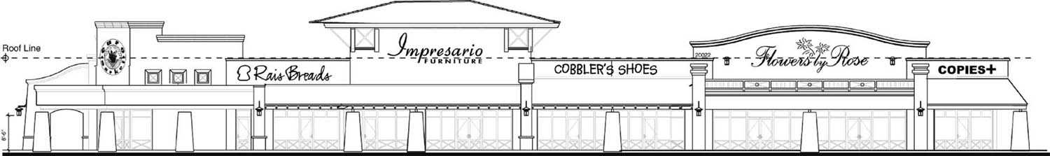
Wall Signs (1)
4.1.5. Wall signs that are placed above the roofline should not exceed eighty percent (80%) of the width or height of the architectural feature to which they are attached. (P)
Rationale: Wall signs should not create a crowded appearance and should be in harmony with the architecture of the building.
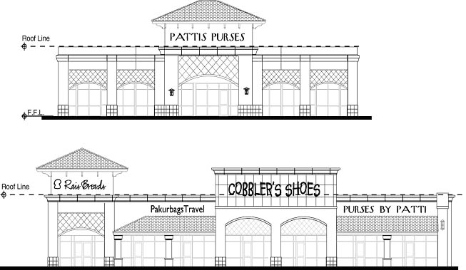
Wall Signs (2)
4.1.6. Wall signs placed on a peaked roof should be structurally integrated into the appearance of the roof, without visible bracing. (P)
Rationale: Signs mounted on a peaked roof should appear to be a part of, rather than distinct from, the roof.
4.1.7. Ground signs placed closer to the building than the width of the sign should not exceed the height of the building, or should be designed to appear to be an integral part of the architecture of the building. (P)
Rationale: Ground signs placed close to a building should be complementary of the building’s design and scale to avoid the appearance of being crowded against the building.
4.1.8. One wall sign within a commercial center, as defined in Section 202, may exceed thirty feet (30') in height provided that it is architecturally integrated into the building facade. Said sign should be limited to a maximum height of forty feet (40') in height. This provision does not apply to commercial centers that have received a height waiver or are located within a zoning district that otherwise allows buildings to exceed two stories or thirty feet (30') in height. (P)
Rationale: The height of wall signs placed upon architectural features should be in proportion to the height of the building in order to be of a complementary scale.
4.2. Location.
4.2.1. Sign locations should be integrated within the design of the site and the adjacent streetscape. (P)
Rationale: Signs should be located to provide their functional purpose of communication, and not dominate the building, the site design, or the adjacent streetscape.
4.2.2. Signs and landscaping should be placed so that they are not in conflict when landscaping reaches full maturity. (P)
Rationale: Although landscaping may not initially appear to obscure a sign, it may significantly reduce or eliminate the sign’s effectiveness unless taken into account in the planning process.
4.3. Function.
4.3.1. Sign placement and materials for multiple tenant occupancies should be delineated in a uniform and consistent manner. (P)
Rationale: Sign content is more comprehensible when it is displayed in a consistent manner and signage causes less visual clutter when it is executed uniformly.
4.3.2. Traffic directionals should be placed to promote safe and efficient traffic flow. (P)
Rationale: Poor placement of signs can confuse motorists and pedestrians and cause potential safely hazards.
4.3.3. Signs should be oriented to promote readability and serve their intended function. (P)
Rationale: Poor orientation reduces the effectiveness of a sign.
E. Specialized Areas.
1. Freeway Mitigation.
1.1. Where noise is, or may be, a detriment to a residence, the following construction techniques should be incorporated:
(A) Noise walls a minimum of eight (8) feet in height should be constructed of 8" minimum thick, concrete masonry units (CMU), or of cast-in-place concrete and contain no openings unless they are above the minimum height required for adequate noise mitigation.
(B) Residential units should be limited to single story for lots abutting the freeway.
(C) Use double-pane windows and solid-core or insulated exterior doors for freeway facings.
(D) Reduce noise transmission through exterior walls by increasing the mass of wall materials, such as an additional layer of gypsum board, or by using staggered wall studs.
(E) Where corner lots back onto the freeway right-of-way, noise walls should "wrap around" and continue along the street side of the lot. (P).
Rationale: Noise studies conducted by HUD have concluded that the listed building techniques will reduce the level of noise that reaches the living space.
1.2. Where lots are to be platted adjacent to an undesigned section of freeway, perimeter walls should be designed to accommodate 12' high walls and constructed to 8' high so that the wall may later be increased in height by a public agency. Need for the additional 4' will be determined after freeway is designed. However, if a council-adopted freeway specific plan calls for a different height, or the developer conducts a noise study, the site-specific data and walls heights will take precedent. (P)
Rationale: Until the freeway design is complete, it is difficult to determine the appropriate height for perimeter walls. However, it has been determined 8' will be adequate for most configurations.
1.3. The number of lots that abut a freeway right-of-way should be minimized. (P)
Rationale: By exposing fewer homes to the negative impacts of the freeway, the neighborhood will be less impacted.
2. Canal Banks. All development in the City of Phoenix on both public and private land adjacent to the Highline, Grand, Arizona, and Western canals which is subject to development review shall comply with the following Canal Bank Design Guidelines. Such development which uses Salt River Project (SRP) canal bank right-of-way or Flood Control District (FCD) Arizona Canal Diversion Channel (ACDC) right-of-way shall also be under a licensing agreement with the City of Phoenix and SRP, and the FCD as required. The Canal Bank Design Guidelines shall control if they conflict with other Citywide design guidelines. The Canal Bank Design Guidelines which are requirements shall control if they conflict with other Citywide development standards. The Canal Bank Design Guidelines which are presumptions and which a developer satisfies shall also-control if they conflict with other Citywide development standards.
2.1. Physical Access.
2.1.a. Public Accessibility.
2.1.a.1. No development project shall build closer than fifteen (15) feet to the water’s edge. (R)
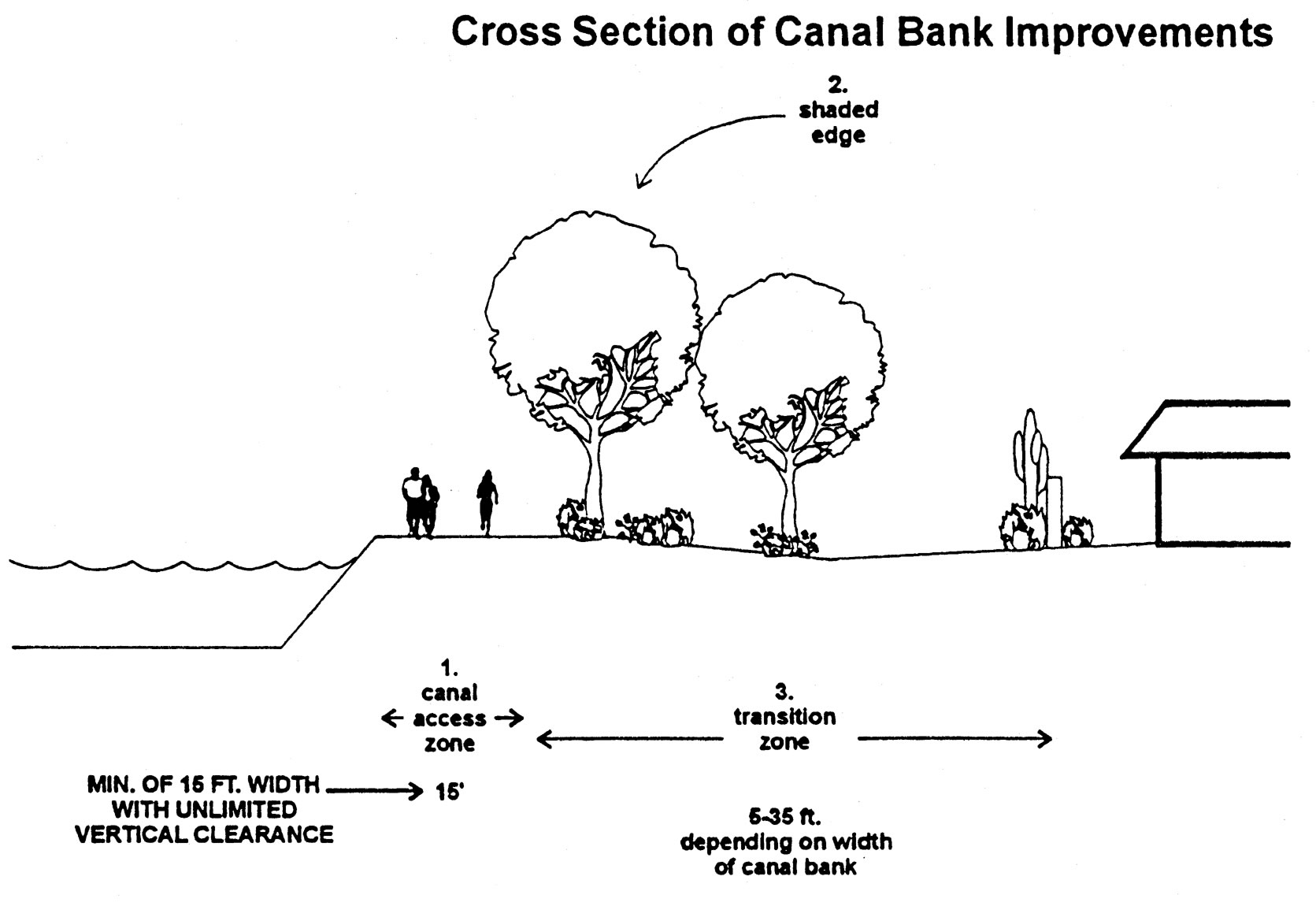
Cross Section of Canal Bank Improvements
2.1.a.2. No development shall restrict access to the canal by building to the water’s edge or erecting a barrier across the canal bank which prevents nonvehicular travel on the canal banks. (R)
2.1.a.3. Developments adjacent to canal banks which provide unrestricted access to their sites from public streets, including retail/commercial, mixed-use, office, research parks and school/park uses, also shall provide public access from canal banks to the site during public hours of operation to promote use of alternative modes of transportation if the canal bank grade is one (1) foot or less above or below the grade of the private property at any point adjacent to the canal bank. Any gates shall be self-closing and self-latching. (R)
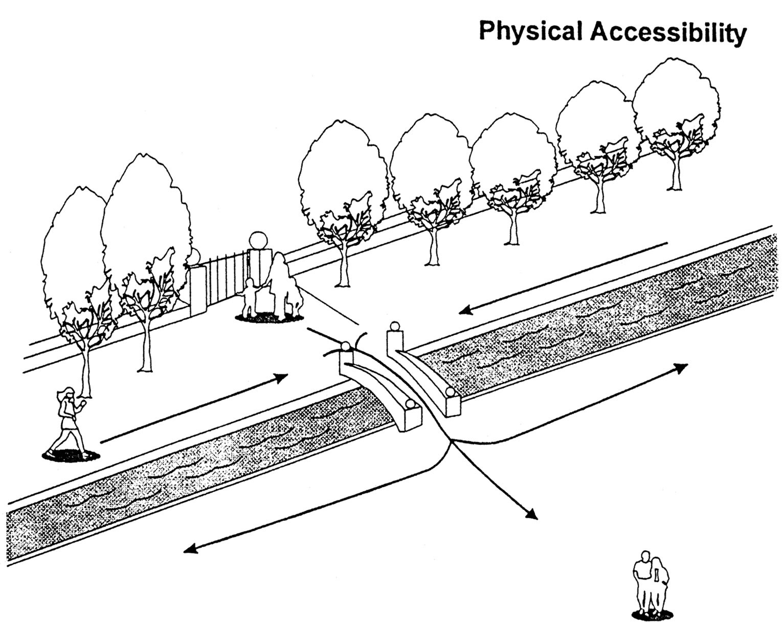
Physical Accessibility 1
2.1.a.4. Developments adjacent to canal banks which provide unrestricted access to their sites from public streets, including retail/commercial, mixed-use, office, research parks and school/park uses, also should provide public access from the canal banks to the site during public hours of operation to promote use of alternative modes of transportation if the canal bank grade is greater than one (1) foot above or below the grade of the private property at any point adjacent to the canal bank. Any gates should be self-closing and self-latching. (P)
2.1.a.5. Where canal access points exist (cul-de-sac, alleys, streets, and utility rights-of-way), adjacent development should provide landscaping on the development’s property. (P)
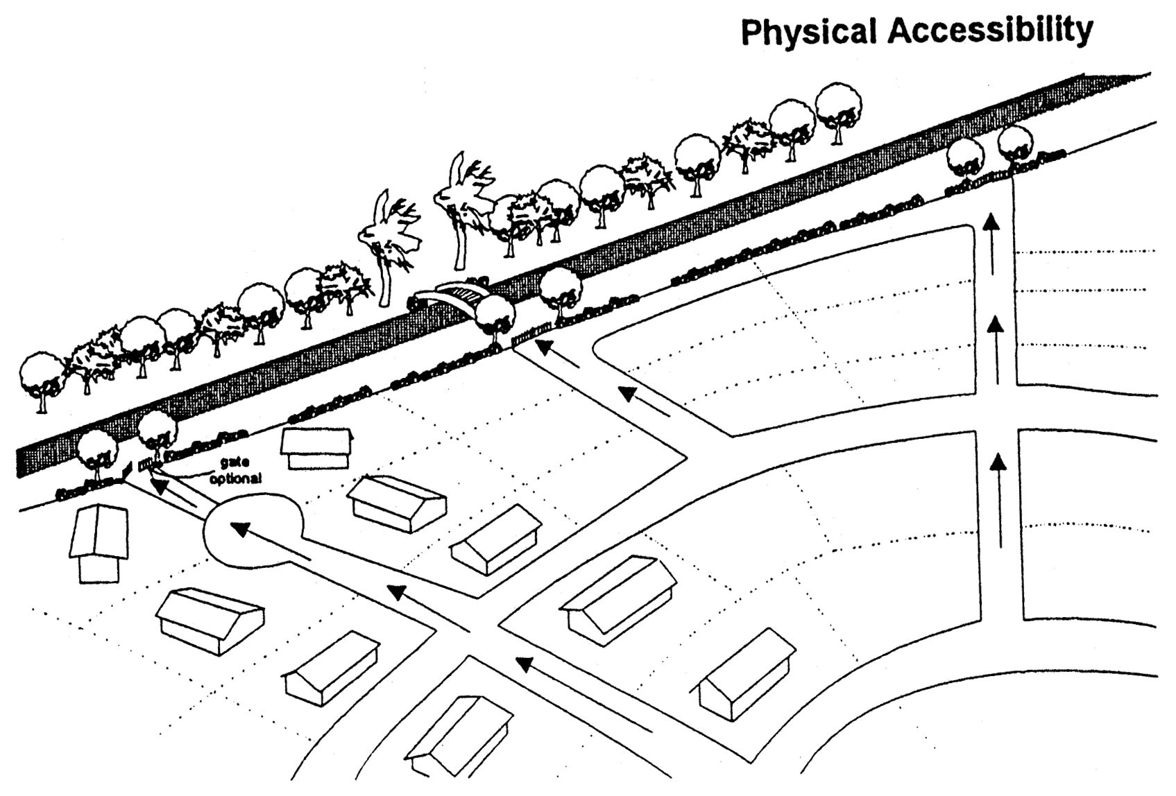
Physical Accessibility 2
2.1.a.6. Public pedestrian bridges across the canal are encouraged to link neighborhoods, commercial, recreational, and public uses. (C)
2.1.b. Private Accessibility - For Property Residents/Owners/Tenants.
2.1.b.7. Private yards in residential neighborhoods should be encouraged to have private, self-closing, self-latching pedestrian gate access from the yards to the canals. (C)
2.1.b.8. Residential and non-residential developments with common open space shall provide access to the canal banks with self-closing, self-latching gate(s) which may be keyed for resident/owner/tenant use if the canal bank grade is one (1) foot or less above or below the grade of the private property at any point adjacent to the canal bank. (R)
2.1.b.9. Residential and non-residential developments with common open space should provide access to the canal banks with self-closing, self-latching gate(s) which may be keyed for resident/owner/tenant use if the canal bank grade is greater than one (1) foot above or below the grade of the private property at any point adjacent to the canal bank. (P)
Rationale (3.1.a.1-3.1.b.3): Developments shall not restrict access to the canal by building to the water’s edge. Canal banks should be a primary component of pedestrian (including modes of transportation necessary for people with disabilities), bicycle and equestrian pathways. Public accessibility to the canal system is essential in order to reinforce and preserve the system as a valuable public resource. Accessibility includes not only physical accessibility, but visual and temporal as well. Most people see canals when crossing on arterial streets. This exposure should be enhanced, not diminished.
2.2. Visual Accessibility.
2.2.1. No canal shall be placed underground. (R)
2.2.2. Solid walls above three feet should not be allowed, except to screen open industrial uses, to provide visual access between the canal banks and the adjacent development. (P)
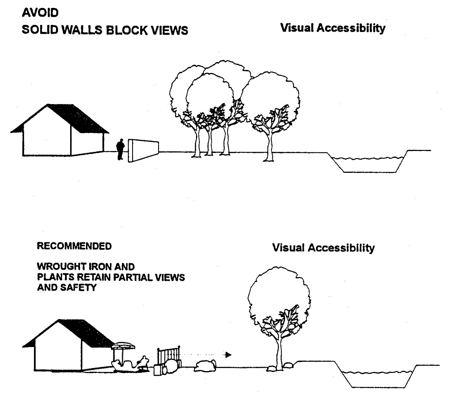
Avoid Solid Walls Block Views
2.2.3. Solid walls abutting the canal bank shall not exceed six hundred sixty (660) feet in length except for open industrial uses. (R)
2.2.4. Not withstanding the provisions of Section 703 of the Zoning Ordinance, wrought iron fences up to eight feet in height shall be allowed. (R)
2.2.5. Significant view corridors of the canals from contiguous public spaces including existing streets and open spaces shall be preserved. (R)
2.2.6. Wherever possible, combine existing views of canals with views of significant natural features (e.g. Camelback Mountain, South Mountain). (C)
Rationale (3.2.1-3.2.6): Views of the canal system should be enhanced and preserved as part of the public realm. Significant historical features of the canals, such as the Pueblo Grande Museum, Park of the Four Waters, and Arizona Falls should be visually integrated into the adjacent canal system. Canals should be placed underground only in cases of property hardship to further the public good; this is consistent with SRP’s policy that canals remain open unless there is a higher public need and the continuity of the system is maintained.
2.3. Landscaping Features within Canal Rights-of-Way.
2.3.1. New trees and shrubs along the canal banks shall be selected for their ability to provide shade and a visual amenity. Modifications to spacing may be required by SRP subject to site specific canal widths or by Development cervices or SRP or the FDC along the ACDC subject to access needs or the slope of the canal bank adjacent to the private property. (R)
2.3.2. Low water use landscape materials shall be used in canal bank development. Landscape materials shall be selected from the Phoenix low water use plant list and SRP’s approved plant list. (R)
2.3.3. An irrigation system shall be designed for canal right-of-way landscaping and installed by the public or private development which is subject to design review, using a municipal water supply or private source. (R)
2.3.4. Landscaping of canal banks shall be designed to avoid drainage into the canals as runoff and into the ACDC as runoff unless the existing and prevailing drainage is already into the ACDC. (R)
Rationale (3.3.1 - 3.3.4): The overall landscape character of canal development should be appropriate to the Sonoran Desert and/or should reflect significant natural areas adjacent to the canals.
2.4. Safety.
2.4.1. Grade separations should be installed at all arterial street crossings to ensure continuity of canal paths while providing maximum safety from vehicular traffic. (C)
2.4.2. The developer shall participate in the installation of one or more of the following safety measures, or an acceptable alternative, based on the determination of the developer’s proportionate share of the cost due to the level of impact of the project on canal bank usage: (R)
(A) Pedestrian activated traffic signal(s) if such a signal meets national standards;
(B) A pedestrian/cyclist safety island within the middle of the road right-of-way,
(C) Clearly marked crosswalk with motorist warning signs,
(D) Vehicular rumble strips to warn oncoming traffic that they are approaching a pedestrian crossing;
(E) Curb ramps;
(F) Street identification and safe crossing method signage;
These alternatives require approval of the Street Transportation Department
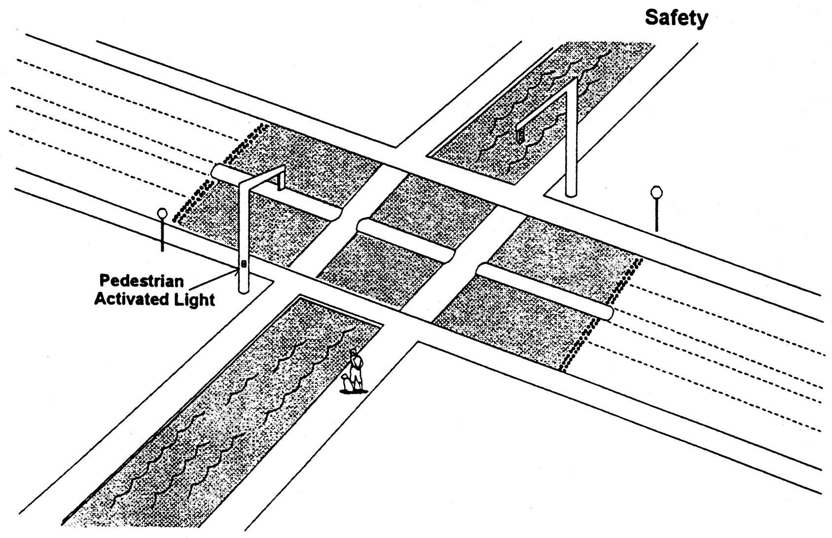
Safety
2.4.3. Lighting shall be incorporated in underground pathways, such as those which pass under a street. (R)
2.4.4. No lighting placed within canal right-of-way shall shine onto private residential property. Light intensity shall not exceed one (1) foot candle at the residential property line. (R)
2.4.5. Vegetation height or massing shall not become a safety hazard by restricting visibility within the canal right-of-way. (R)
2.4.6. All alley and street access points perpendicular to the canals should be well lighted and clearly marked. (P)
2.4.7. Placing emergency call boxes which are accessible to wheelchair users and are hearing aid compatible at major arterial crossings is encouraged. (C)
Rationale (3.4.1-3.4.7): Every use of the canal right-of-way should strive to maximize public safety. All potential designs must be analyzed to ensure that the general publics activities are directed either to areas separated from the open channel and overhead electrical system or to areas where safety features are incorporated.
2.5. Power Easements.
2.5.1. All canal uses shall be designed and planned with the coordination of the appropriate power jurisdiction. (R)
2.5.2. No permanent use area (e.g. rest areas) shall be allowed within a fifty (50) foot radius of the center line of any high voltage power tower. (R)
2.5.3. Only trees on the SRP approved plant list shall be planted within the SRP power easement. (R)
2.5.4. Any conductive materials used within power easements shall be properly grounded. (R)
2.5.5. Pedestrians and cyclists should be kept away from power towers with minimum three and one-half (3.5) foot high barrier plantings. (This design must still allow necessary service access.) (P)
Rationale (3.5.1-3.5.5): Of primary importance to the function of the canal system is the ability for SRP to maintain and operate its water delivery service and adjacent power system.
2.6. Adjacent Land Uses.
2.6.1. Parks which abut a canal shall incorporate the canal banks and trails into the design of the park. (R)
2.6.2. Developers of new multi-family housing developments should face the windows and balconies of some units toward the canal. (P)
2.6.3. Some units in a multi-family housing development should be within five (5) feet of the canal right-of-way. (C)
2.6.4. New developments or redeveloped sites with canal frontage should place land uses near or adjacent to the canal which are compatible with the canal system including:
(A) Open space (public or private);
(B) Other public land uses (libraries, cultural facilities, municipal services);
(C) Single-family housing;
(D) Quasi-public land uses (golf courses, resorts, health clubs, research parks);
(E) Retail/commercial (shopping, entertainment, restaurants, cafes, offices);
(F) Multi-family housing;
(G) Mixed-use (office/retail/housing) development. (C)
2.6.5. In order to enhance the visual experience for canal bank users and to promote safety, the frontage along canal banks of adjacent land uses such as storage facilities, parking garages, and outdoor storage should be minimized. (P)
2.6.6. Open industrial land uses and garages shall be screened. (R)
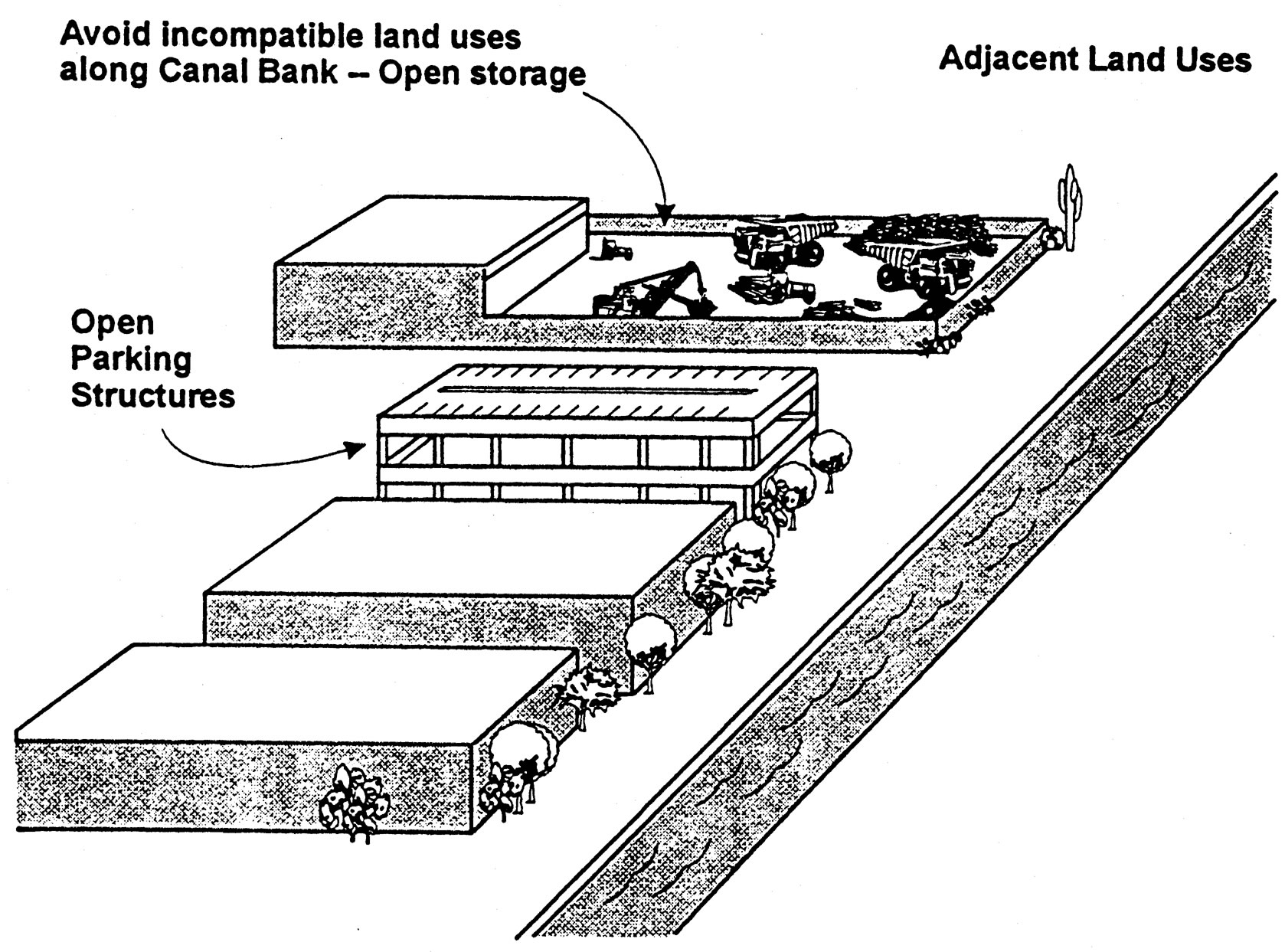
Industrial Land Uses and Garages
2.6.7. Public spaces within private developments should be located adjacent to the canal in order to achieve integration with the public system of the canal. (P)
2.6.8. Shared use of existing parking lots for canal uses is encouraged. (C)
2.6.9. Parking lots shall be designed so that they do not drain into canals. (R)
Rationale (3.6.1-3.6.9): Canals should be treated as an asset to be integrated with adjacent land use.
2.7. Urban Area/Canalscape Treatment - Design Continuity. For purposes of this section, an urban area shall be defined as one in which commercial, office, resort/hotel, or public assembly development of four (4) or more stories or a floor area ratio greater than or equal to 1.0, or residential development of twenty-five (25) or more dwelling units per acre abuts a canal bank.
2.7.1. Development which uses canal bank right-of-way at canal waterline edges in urban areas should be marked with curbs, railings, change in grade, change in paving materials, or landscape treatment subject to approval by Salt River Project. (P)
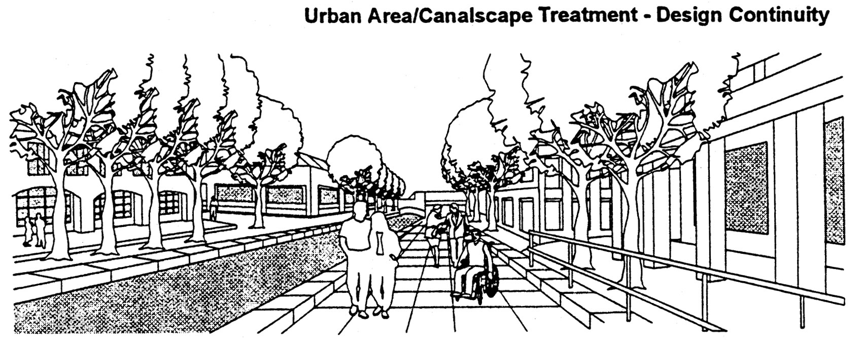
Design Continuity
2.7.2. Canal bank right-of-way which is used for development in urban areas should be lighted at the pedestrian level at a minimum power of one (1) foot candle. Lighting fixtures on poles should not exceed fifteen (15) feet in height. (P)
2.7.3. Buildings adjacent to the canal bank should be constructed along the canal right-of-way line ("build-to-line") or a distance of twenty-five (25) feet from the water’s edge (whichever is greater) for a minimum of fifty percent (50%) and a maximum of eighty-five percent (85%) of the building(s) canal facade. (P)
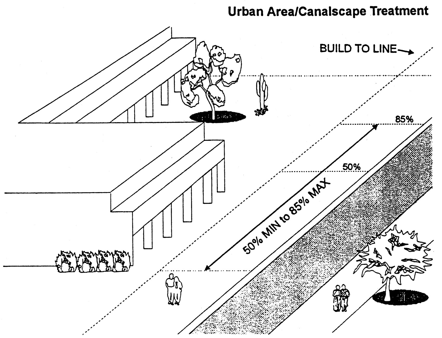
Urban Area Canalscape Treatment
2.7.4. The area between the portion of the structure not constructed to the "build-to" line and the canal right-of-way should be a public or private pedestrian area with a hard surface including street furniture, functional planting, and other pedestrian amenities and may include a twelve (12) foot wide arcade. The hard surface should include stone, unit paver concrete, fired brick, or poured in place concrete. Other design characteristics of a pedestrian area should include outdoor furniture, shade structures to enhance pedestrian comfort, low-water use fountains to passively cool immediately adjacent outdoor areas, cool towers in appropriate areas, low water use shade tree bosque, lighting, and sloping to avoid drainage of storm water and runoff into the canals (P)
2.7.5. The ground floor arcade portion as described in 3.7.4 should contain a mix of pedestrian-oriented building uses. (C)
2.7.6. Buildings or portions of a building constructed on the "build-to" line should be stepped back a minimum of ten (10) for each floor above the first floor. (P)
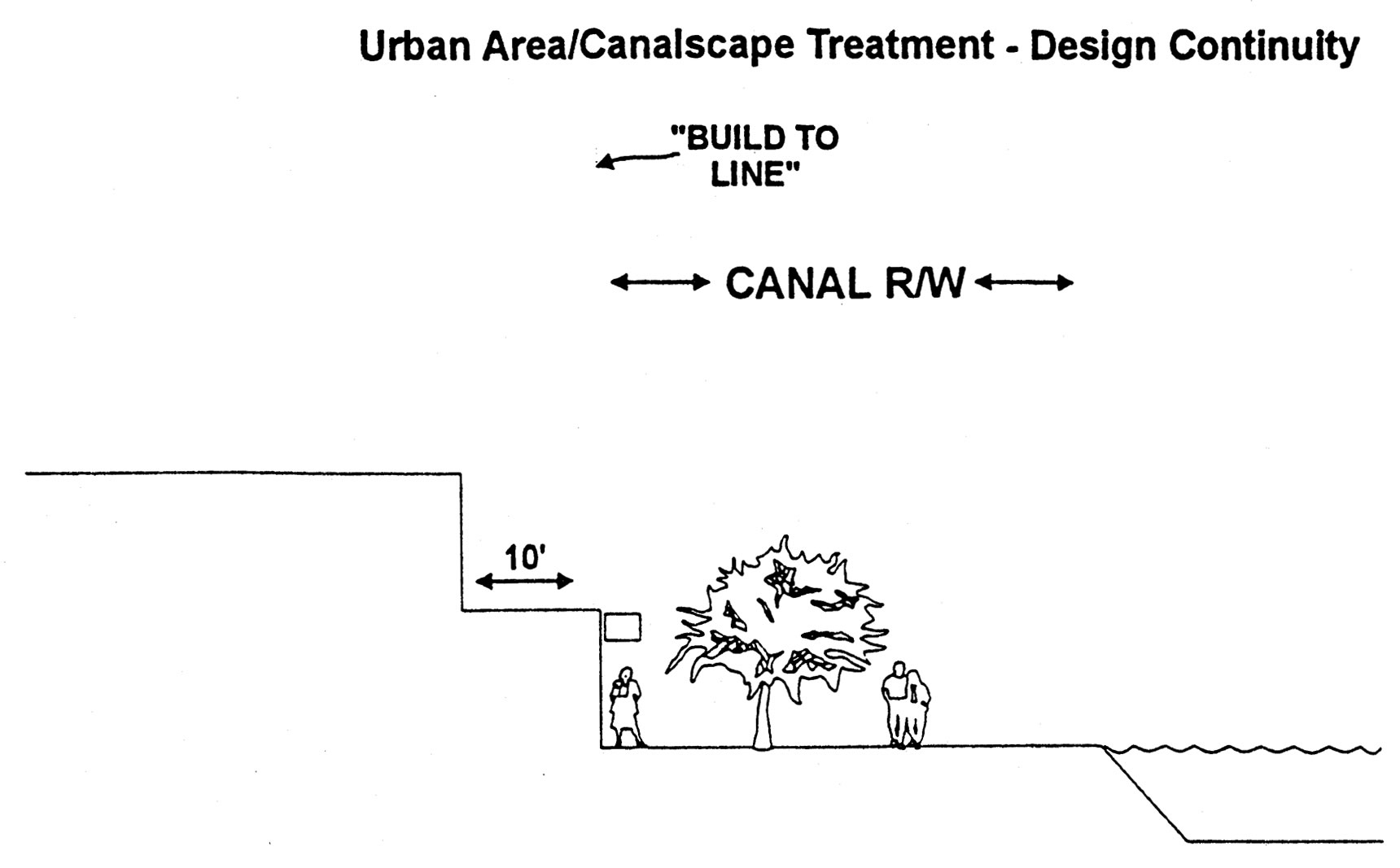
Urban Area Canalscape Treatment Design Continuity
Rationale (3.7.1-3.7.6): An urban area is an area which generates high levels of activity and has a strong pedestrian emphasis. Urban area land uses along the canal banks would include retail, restaurants, offices, resort/hotel, cultural facilities, and high density residential. The canal right-of-way should take on the characteristics of a highly developed urban paseo. Building design should help accommodate outdoor spaces for the pedestrian adjacent to the canals in an urban area. One of the goals in urban areas is to line the canal with activities that are of interest to the canal bunk users.
2.8. Suburban Area/Canalscape Treatment - Design Continuity. For purposes of this section, a suburban area shall be defined as one in which commercial, office, industrial, resort/hotel or public assembly development of less than four (4) stories or a floor area ratio less than 1.0, or residential development of less than twenty-five (25) dwelling units per acre abuts a canal bank.
2.8.1. Suburban areas of the canal right-of-way system should have the characteristics of a linear park. The design characteristics should include the following:
(A) Periodic public access points, as discussed in Guideline 7.1, physical accessibility, every 1/4 mile minimum; (P)
(B) Low water use plant materials when the canal right-of-way is landscaped. (P)
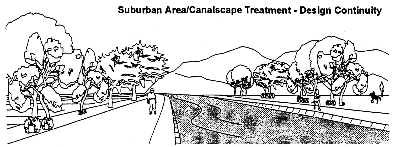
Suburban Area Canalscape Treatment Design Continuity
2.8.2. Design of the canal bank right-of-way should also include the following:
(A) Optional shade structures to enhance pedestrian comfort;
(B) A park-like system of multiple use trails. (C)
Rationale: A suburban area is an area which generates low levels of activity and which is sensitive to primarily adjacent residential land uses. A suburban area would include single family housing, parks, golf courses, and neighborhood retail uses.
3. Sonoran Preserve Edge Treatment Guidelines. All property adjacent to the proposed or acquired Sonoran Preserve boundary having a minimum continuous common boundary of five hundred feet shall be subject to edge treatment.
|
Single Family Land Use |
All Other Land Uses |
|---|---|
|
A lot or parcel depth or width, plus adjacent right-of-way, not to exceed 300 feet |
A lot or parcel depth or width, plus adjacent right-of-way, not to exceed 1,200 feet |
The intended Sonoran Preserve includes those lands identified on the "Sonoran Preserve Master Plan" as approved by City Council on February 17, 1998. The boundary of the preserve lands shall be the edge of those areas identified on the Sonoran Preserve Master Plan. These guidelines shall apply to development adjacent to preserve lands which at the time of preliminary site plan or preliminary plat approval:
•The land is owned by the City for preserve, or;
•The land has been stipulated by zoning case for preserve, or;
•Active negotiations are in progress for dedication or purchase of the adjacent preserve land by the City.
Or it includes all projects for which preliminary or final Planning and Development Site Plan or subdivision approval has been obtained prior to the effective date of this ordinance, these design guidelines shall not apply. If a major amendment to the proposed use of configuration of a parcel of land adjacent to the Sonoran Preserve is sought after adoption of this ordinance these guidelines should be applied in a manner consistent with the change.
Where edge treatment design guidelines conflict with other development standards, the most restrictive shall apply.
3.1. Plan Submittal.
3.1.1. A site analysis shall be required with the submittal of a preliminary site plan, subdivision plan, or lot split to the City. The site analysis is a tool to assist in determining areas to be preserved and areas to be developed. City staff shall review the applicant’s proposal and approve modifications with regard to proposed construction areas, areas to remain undisturbed, road corridor, storm water retention areas, and potential public or private utility areas. The base for the site analysis shall include a current aerial photo at a scale to be determined by staff. This will vary dependent upon the size of the proposed project. Specific areas within a large project may need to be provided at a suitable scale if more detail is necessary. The following information shall be included on the site analysis, as required or as modified by City staff. items A through K below are requirements. (R)
(A) Land contours at a scale determined by staff;
(B) A slope analysis identifying slopes of five percent and greater in increments of five percent where it is evident that slopes exceeding five percent transition to hillside areas of slopes exceeding ten percent;
(C) Identify wash corridors and preliminary hydrologic information for the contributing watershed (i.e., cfs flows, on-site and off-site, sheet flow direction);
(D) Identify the limits of riparian vegetation associated with washes and other areas where water concentrations have created dense stands of vegetation. Aerial photos can be used to map the limits of notable vegetation.
(E) Identify potential view corridors to public or private open space areas along wash or roadway corridors;
(F) Identify potential land uses and development areas;
(G) Identify the projected one hundred-year floodplain and floodway boundary as required by the federal emergency management agency (FEMA) and one hundred-year twenty four-hour flow boundaries for washes not addressed by FEMA per ARS Standard 2-96 or the Drainage Design Manual For Maricopa County. If the width is to be identified at the time of rezoning, this information may be required;
(H) Provide evidence of a record check through the Arizona State Museum for Archeological Sites, confirm with the City archeologist and identify any sites;
(I) Identify public trail and park locations using the approved master trails plan and master edge plan from the City, including on-site and off-site connections;
(J) Identify potential subdivision layout or a site plan;
(K) Identify potential arterial, collector and local street alignments.
Rationale: Rigorous analysis of a site prior to preparing the site plan or subdivision layout will allow preservation of important site features, such as wash corridors, and riparian stands of vegetation and reduce hazards from potential flooding and other natural occurrences.
3.2. Signage.
3.2.1. All signs shall be approved through a Comprehensive Sign Plan, per Section 705e.2. (R)
Rationale: A higher level of aesthetics will be achieved through a comprehensive sign plan, which addresses the quality and consistency of appearance of all signage on a site.
3.3. Grading/Drainage.
3.3.1. Box gabions and concrete channels should not be allowed unless designed to look natural in the desert setting through color, texture, landscaping or other means. (P)
Rationale: Box gabions and concrete channels create an unnatural appearance. Additionally, concrete channels can contribute to drainage problems where they interface with natural washes.
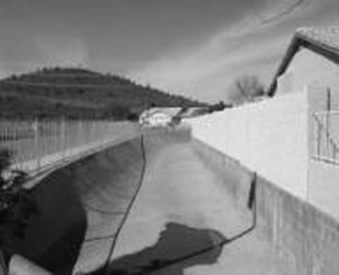
Concrete channels do not look natural
3.3.2. Riprap should not be used at the Sonoran Preserve edge to mitigate drainage unless used with restraint and designed to blend with the desert setting through color, texture, soil plating, landscaping and other means. (P)
Rationale: Where engineered erosion control is necessary, a more natural looking drainage way will preserve the scenic qualities of the desert.
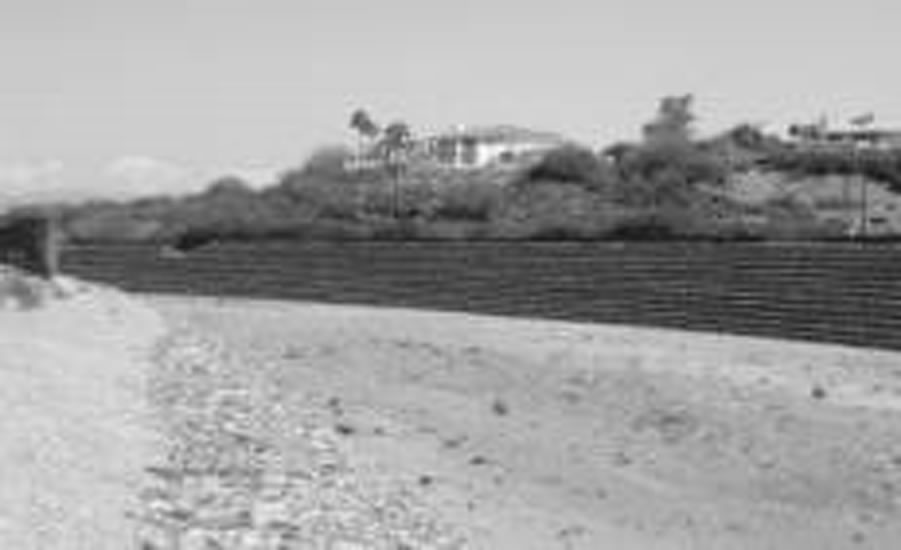
Landscaping and other means improve appearance of rip rap
3.3.3. Where culverts are constructed, minimize the concrete while providing the opening required by the hydrology and to blend with the adjacent desert via materials and landscaping after construction. (P)
Rationale: Culverts can be visually obtrusive. Design can minimize visual impact by minimizing the concrete structure and blending materials and colors.
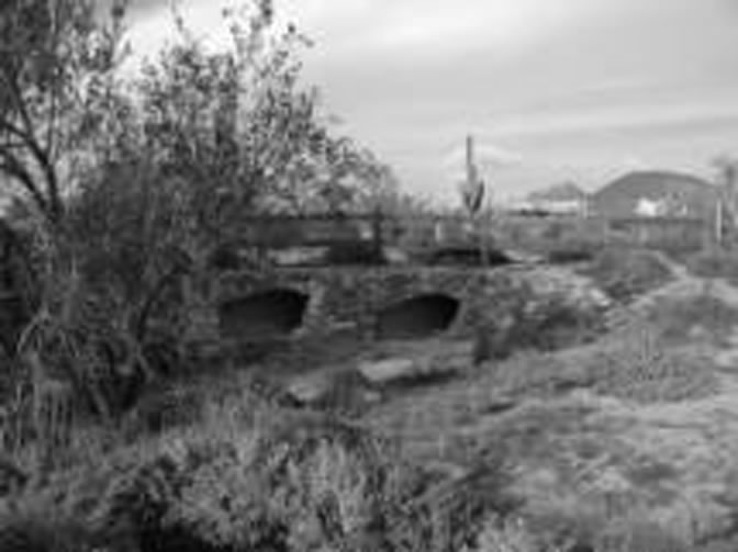
Culvert designed to blend
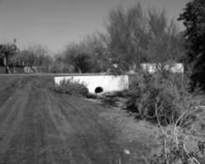
Culvert not designed to blend
3.4. Walls/Fencing.
3.4.1. When separated from the Sonoran Preserve by an arterial or collector street, residential subdivision or commercial perimeter walls, and other walls should vary by a minimum of four feet every four hundred lineal feet to visually reflect a meandering or staggered setback. Design features should be used to break up the appearance of a long, straight wall. Such design features may include, but should not be limited to planters, decorative walls less than three feet in height, and dense landscaping adjacent to the wall to screen it. if design features other than meandering or staggered setbacks are used, the developer should demonstrate how the design visually breaks up long, straight wall appearance and the plan must be approved by the City. (P)
Rationale: Providing a variation in the appearance of a wall line through allowing the wall to meander or be offset or through another design feature will visually soften the edge of development adjacent to the preserve.
3.4.2. Walls and fences should be designed to blend into the desert environment by addressing the color, materials, and alignment of the structure. (P)
Rationale: Because straight lines rarely occur in nature, addressing the alignment as well as the color of walls and fences will help blend development into the desert setting.
3.5. Landscape Architecture.
3.5.1. Plants in public open space, public or private common areas, other than turf for active uses, or along public or private rights-of-way shall be from the approved plant species list (Appendix A). Palm trees and other plants specified on the prohibited plant species list (appendix B) shall not be allowed at trailheads, open spaces, or landscape setbacks adjacent to the Sonoran Preserve. (R)
Rationale: Sonoran desert plants would make an effective landscape statement or focal point that would reflect the Arizona Desert Southwest. Palm trees are not indigenous and are invasive; other non-native species also create problems in the desert environment.
3.5.2. All lot grading and construction areas shall be clearly marked by a chain link fence, an orange net fence with posts fifty feet on center, or an equivalent approved by the City, to minimize impact during construction. A sign shall be posted on the fence to make all parties involved in construction aware of the purpose of the fence. Construction fence is to remain intact until completion of construction. (R)
Rationale: Defining and containing the allowed grading area prevents overlap into areas designated for preservation. where disturbance must occur, the impact should be minimized.
3.6. Trails/Paths.
3.6.1. Access points to the Sonoran Preserve shall be approved by the City. Construction of unauthorized access points shall not be allowed. (R)
Rationale: The parks and recreation department has specific needs and criteria for access points to open space areas that they manage.
3.6.2. Public access, via a public collector or arterial street, or local street as approved by the City, for community or regional level use should be provided to a City developed and maintained trailhead or activity center within the Sonoran Preserve at approximately one per mile of linear edge, or as designated on the Sonoran Preserve Master Edge Plan. (P)
Rationale: The master edge plan or one mile standard will assure adequate public access to the substantial amount of Sonoran Preserve Land. Adequate public access is a necessary element to minimize impact within neighborhoods.
3.6.3. All residential development should provide a minimum of one unrestricted public access to a perimeter trail in the Sonoran Preserve for neighborhood use at a rate not to exceed four access points per mile of the Sonoran Preserve Edge, or as approved by the City. There shall be no required access points within a gated community except to serve the residents of such community and access points shall not be required within 100 feet of a gated community boundary. Site conditions may impact the exact location of the access point. The width of the access shall be a minimum of forty feet and a maximum of fifty feet. (P)
Rationale: Access to the Sonoran Preserve should be provided within easy walking distance for area residents. These access points also serve to reduce the demand for parking at primary and secondary trailheads.
3.6.4. A paseo adjacent to the Sonoran Preserve or a Paseo adjacent to unimproved open space that is adjacent to a Sonoran Preserve Trail shall count as part of the required improved open space for a development provided the paseo provides public access as approved by the City. (P)
Rationale: In combination with providing an open edge treatment, paseos provide access and activity at the edge of the Sonoran Preserve.
3.7. Open Edge Treatment.
3.7.1. A minimum of sixty percent of the edge shall consist of open edge treatment. (R)
(A) Open edge treatment shall not include private undisturbed open space or public preserve which is less than 50' in width and less than 100' in depth. in these cases the edge boundary will be the shortest distance between two points of private improvements.
Rationale: Sonoran preserve is purchased with public funds to serve as a visual and recreational amenity for all. The 60% edge is consistent with the voter approved general plan 2002 to provide adequate visual & physical access to the public land.
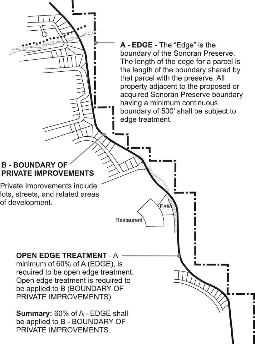
Edge boundary graphic
3.7.2. The open edge treatment may be shown on an individual project basis, in conjunction with a Planned Community District (PCD), or in an approved functional unit edge treatment plan. A master open edge treatment plan submitted in conjunction with a Planned Community District (PCD) or a functional unit of a PCD should verify that the required percentage of edge treatment is provided based on the overall master development rather than by parcel. The master open edge treatment plan allows the incorporation of facilities and open space available to the public, such as parks, schools, recreational facilities and retention areas, as long as the overall required percentage of edge treatment is reasonably dispersed throughout the PCD as approved by the City. (P)
Rationale: Open edge treatment encourages the sense of ownership of the Sonoran Preserve from the greater community, rather than only those located at the edge. Facilities such as parks, schools, recreational facilities and retention areas allow both visual and physical access to the preserve. typically, these are separate parcels, where they would provide no edge credit to developers. By allowing them to be included in a master plan for open edge treatment, siting at the edge is encouraged.
MASTER EDGE PLAN COMBINES EDGE TREATMENT ON DIFFERENT PARCELS
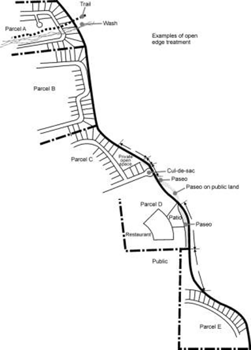
Master edge plan
3.7.3. In development adjacent to the Sonoran Preserve Edge, open edge treatments shall be used on the required edge in accordance with the following table (P):
|
MINIMUM 30% (1) |
MAXIMUM 70 (1) |
MAXIMUM 30% (1) |
|---|---|---|
|
Single loaded public street or single loaded private street with public access easement (non-gated) |
Public school |
Single loaded gated private street |
|
Public park |
Shared parking as approved by the City (2) |
Gated private street cul-de-sac (2) |
|
Public street T-intersection (2) |
Gated private street T-intersection (2) |
|
|
Municipal facilities such as fire station, police station, community center, or library |
Wash corridor |
|
|
Private undisturbed open space |
Retention or detention basin graded to blend (2) |
|
|
Private improved open space |
Creative options |
(NOTE: The percentages may be modified if approved by the Planning, Parks And Recreation, and Planning and Development Department.)
1One or a combination of edge treatments provided multiple treatments do not overlap.
2Maximum of 1,000 feet without alternating a different edge treatment except for parkways, arterials, and collector streets.
Rationale: The Sonoran Preserve is a public amenity, and citizens should easily enjoy the preserve.
Open edge treatments are defined as follows:
(1) Single loaded public street. Single loaded streets allow public access, especially visual access. They contribute to the sense the Sonoran Preserve is "ours" rather than "mine."
(2) Public park. A public park may be designed to provide visual or physical access to the Sonoran Preserve for the public.
(3) Paseo. Where identified on the Sonoran Preserve Master Edge Plan, a paseo should be placed along the Sonoran Preserve Edge to provide connectivity and public access between the preserve and adjacent development. Paseos should count both as open edge treatment and as part of a development’s required open space, per the zoning district, where the paseo is on private land within a public easement. Where a paseo is constructed by a developer on adjacent public land, it should count as open edge treatment only. A paseo may have room for outdoor seating and special activities like outdoor dining or public gathering areas. The paseo may be designed to meander between an easement and the Sonoran Preserve. Private property outdoor uses may be placed in the easement but not on the Sonoran Preserve. All design is subject to review and approval by the City. Paseos are hard-surfaced, ADA accessible paths a minimum of sixteen feet wide on commercial or multi-family parcels and a minimum of twelve feet wide when adjacent to single family subdivisions. The intent of a paseo along the edge of development is to provide access and connection to and from Sonoran Preserve Trails, and to and from nearby development that might provide services or entertainment.
EXAMPLES OF PASEOS
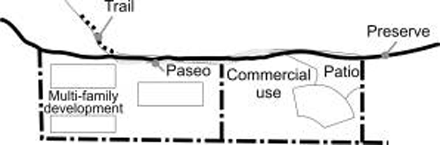
Paseos
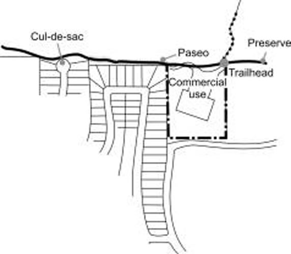
Paseos
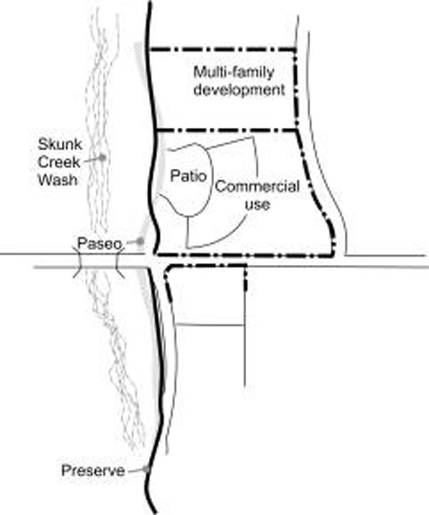
Paseos
(4) Municipal facilities. Municipal facilities such as a fire station, or police station, community center, or library may be designed to provide visual or physical access to the Sonoran Preserve for the public.
(5) Private undisturbed open space. Private undisturbed open space, a minimum of 50 feet in width and a minimum of 100 feet in length.
(6) Private improved open space. Private improved open space located between the Sonoran Preserve or undisturbed open space and an adjacent street. Private improved open spaces provide a connection to public open spaces and may serve necessary purposes, such as retention.
Adjacent Open Space May Be Unimproved Or Improved
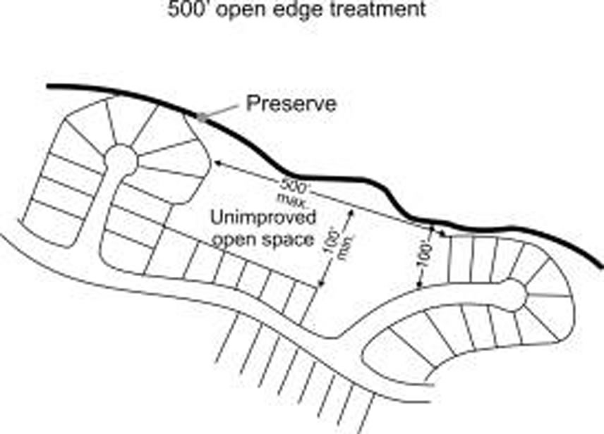
500' open edge treatment
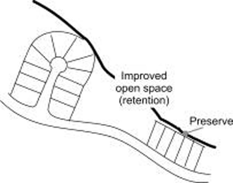
500' open edge treatment
(7) Public school. Public schools may provide visual access to the Sonoran Preserve for the public, and may be designed to also provide physical access to the preserve for the public.
(8) Shared parking. Shared parking, as approved by the City, may count toward open edge treatment if it is shared public parking. Shared parking provides a public benefit, but is subject to a joint use agreement developed with the City.
Shared parking is per joint use agreement.
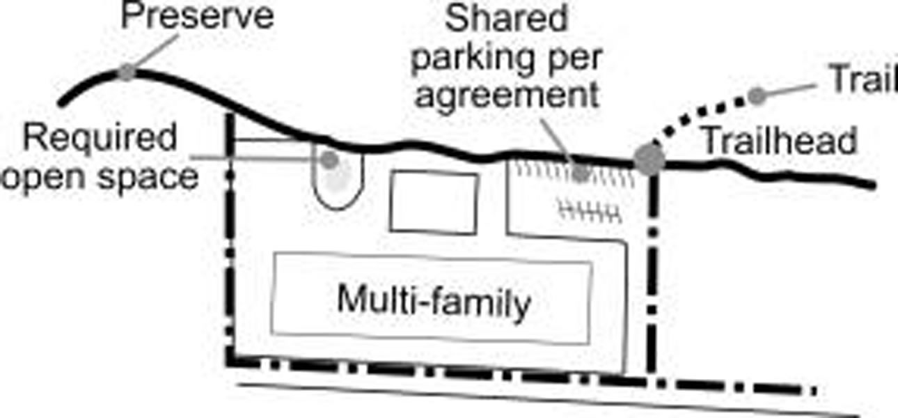
Shared parking
(9) Public street "T" intersection. Where a public street enters a "T" intersection such that an area the width of the street is maintained as undisturbed open space between the street and the Sonoran Preserve that street width should be considered open edge treatment. A "T" intersection provides visual access for the public to the preserve from the developed side of the edge.
Public and private streets may be used, per Table 2.
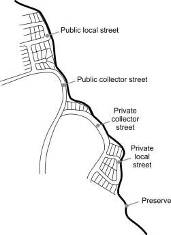
Public & private streets
(10) Public street cul-de-sac. Within a single family development, a street cul-de-sac design provides public visual or physical access to the Sonoran Preserve per a plan approved by the City, with a minimum width of the open space connection defined by a line running along the public or private preserve open space edge connecting the rays of a one hundred forty degree angle measured from the center of the cul-de-sac. Culs-de-sac that open on to the preserve frequently provide visual access for the length of the cul-de-sac and passing streets.
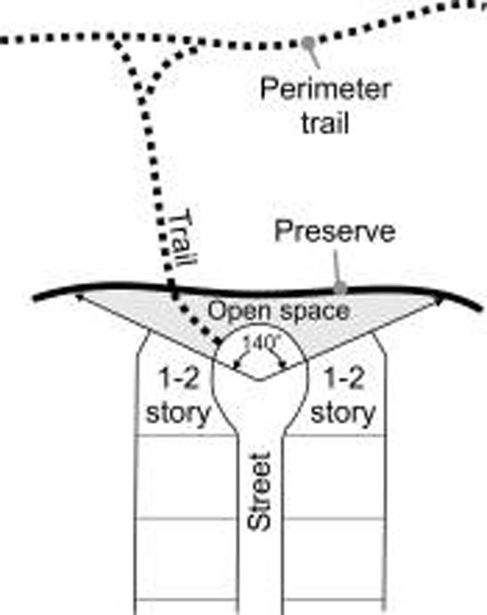
Cul-de-sac
(11) Retention or detention basin. A retention or detention basin, graded to blend with adjacent terrain, provides a visual and physical opening to the Sonoran Preserve, as well as serving drainage functions.
(12) A single loaded private street. Single loaded private streets allow daily access, even if primarily visual. Private single loaded roadways provide access to residents of a development, rather than the greater public.
(13) Private street cul-de-sac. Within a private development, a street cul-de-sac design provides visual or physical access for the residents to the Sonoran Preserve per a plan approved by the City, with a minimum width of the open space connection defined by a line running along the public or private preserve open space edge connecting the rays of a one hundred forty degree angle measured from the center of the cul-de-sac.
(14) Private street "T" intersection. Where a private street enters a "T" intersection such that an area the width of the street is maintained as undisturbed open space between the street and the Sonoran Preserve that street width should be considered open edge treatment. A "T" intersection provides visual access for the residents of a subdivision to the preserve from the developed side of the edge.
Wash Corridors Provide A Connection To The Preserve
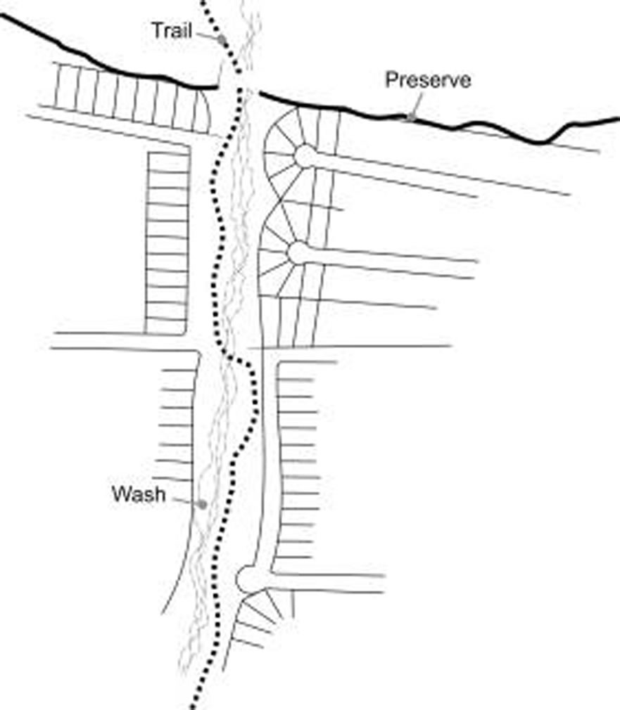
Wash corridors provide connection to preserve
(15) Creative option. An equivalent creative alternative as approved by the City that reflects diversity, together with visual and physical access.
(A) Wash corridor credit. Wash corridors a minimum of 100 feet in width and not to exceed a length of five hundred feet that penetrate the edge of the Sonoran Preserve shall be considered open edge treatment as follows:
|
% OF WASH LENGTH AS OPEN EDGE TREATMENT |
% OF WASH OPEN |
|---|---|
|
25% |
25—50% |
|
50% |
MINIMUM 50% |
|
75% |
25—50% WITH TRAIL |
1Wash corridor credit split proportionately if wash is boundary between different property ownerships.
Creative option. Length of treatment X .20
(B) Artistic walls or wall treatment employing natural materials, planters or forms especially designed to enhance appearance on the public side; such walls designed in consideration of the landscape as opposed to simply responding to the houses.
(C) Enhanced vegetation at the edge to form a transition from the natural condition in the preserve to the inhabited landscape in the subdivision.
(D) Trails leading to preserve at the end of the culs-de-sac not to exceed 150 feet.
(E) Paseos or walks along the edge of the preserve, where the paseo or walk is intended and designed for the use of the general public.
(F) Paseos or walks along the edge of the preserve where the paseo or walk is intended and designed for the use of the general public and coordinated with trailheads of other access points.
(G) Houses positioned so that the front faces the preserve and with garages and garage doors located away from the edge of the preserve.
(H) Houses positioned to face small commons or other private open spaces of at least 100 feet in width and a length not to exceed 500 feet that in turn connect to the preserve at the edge, with garages situated as above (use entire length of space on three sides to measure treatment).
Creative option. Length of treatment X .40
(I) High density housing facing the preserve. Housing with a density of 8 units per acre or higher, designed in coordination with the edge of preserve and to increase awareness of the desert.
(J) Non-residential uses facing the preserve. Schools, parks, recreation facilities, restaurants, cafes and other appropriate retail; office space; and other appropriate uses designated in coordination with the preserve edge and to increase awareness of the desert. (P)
|
Open edge treatment may be included between lots if placed in common tracts, a minimum of 50 feet in width and a minimum of 100 feet in length. The tract shall extend the entire length of the lot. |
|
|
Open edge treatment on preservation lots (PSV) may consist of: |
|
|
1) A preservation or open space easement which is an average of 50 feet in width and 100 feet in length located outside of the building envelope. the easement shall extend the entire length of the lots.OR, |
|
|
Two adjoining lots with a preservation or open space easements(s) that is an average of 50 feet in width and 100 feet in length located outside of the building envelope. The easement shall extend the entire length of the lots. |
|
|
(P) |
Rationale: Private undisturbed open spaces provide a connection to public open spaces and may preserve significant features. however, a minimum size prevents artificially created, minimal buffers.
3.8. Parking/Circulation.
3.8.1. A single loaded street or cul-de-sac opening adjacent to public or private preserve open space shall be designed to:
(A) Follow existing contours to the greatest extent possible to minimize cut and fill;
(B) Minimize the number of wash crossings;
(C) Avoid riparian stands of vegetation and natural rock outcroppings to the greatest extent possible;
(D) Blend cut and fill slopes with the natural desert through such means as chemical color staining, re-vegetation and the use of natural rock materials;
(E) Blend any retaining walls with the adjacent terrain through such means as color, texture and materials. (P)
Rationale: The intent of the roadways is to open up views of the open space it defeats the purpose if construction damages the natural features or creates excessive scarring.
3.8.2. Streets adjacent to the Sonoran Preserve Edge should follow the natural form of the wash or preserve. The final design of the street must be approved by the City. (P)
Roadway Follows The Form Of The Preserve Edge
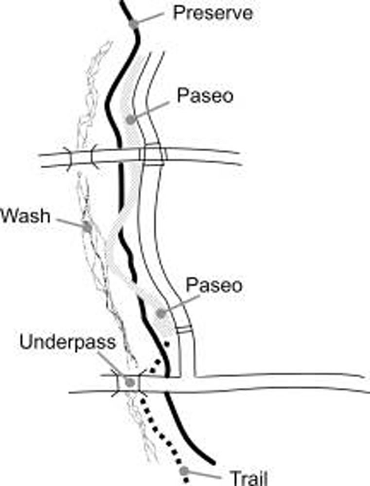
Roadway follows form of Preserve edge
Rationale: Single-loaded streets, when abutting the preserve’s edge, shall have a unique design. A meandering road that follows the wash form or preserve edge reduces vehicular speed and allows for interesting views into the preserve.
3.9. Multi-family.
3.9.1. In multi-family development no private parking except shared parking shall be located within fifty feet of the Sonoran Preserve or private undisturbed open space. (R)
Rationale: The visual impact of a parking lot should not decrease the enjoyment of public or private undisturbed areas for residents.
3.9.2. If units are within fifty feet of the Sonoran Preserve Edge, development shall be designed so that a minimum of fifty percent of residential units adjacent to preserve open space shall face on to, or provide balconies or patios adjacent to the Sonoran Preserve. (R)
Rationale: Development contiguous to the Sonoran Preserve or private undisturbed areas will be able to take advantage of the view afforded by open space, as well as provide informal monitoring of activity in the area.
3.9.3. Multi-family development within twenty five feet of the Sonoran Preserve edge shall be limited to two stories or thirty feet in height from finished floor. One foot of additional height shall be allowed for every two feet additional setback from the preserve edge. (R)
Multiple Stories Are Stepped Back In Height
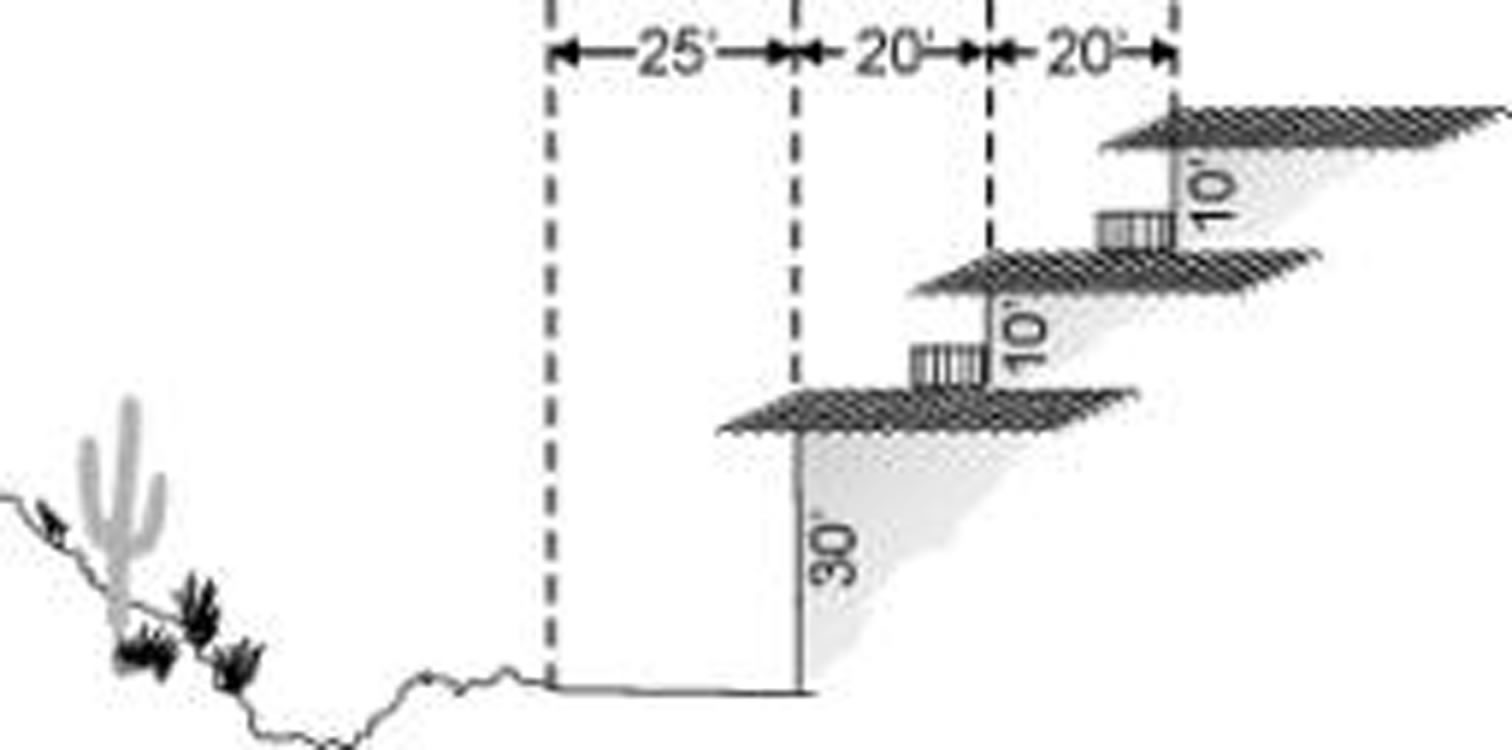
Multiple stories are stepped back in height
Rationale: The height limit adjacent to the edge opens views into the Sonoran Preserve.
3.9.4. In multi-family development adjacent to Sonoran Preserve or adjacent private undisturbed open space, a minimum of fifty percent of the required improved private open space should be located adjacent to the preserve edge. (P)
Rationale: Providing the improved open space for development adjacent to the Sonoran Preserve or undisturbed open space will allow access to the Sonoran Preserve for all residents within the development and encourage activity to or within the preserve areas.
3.9.5. The edge of improved open space contiguous to the Sonoran Preserve edge shall be approximately equal in width and depth, and a minimum of thirty feet and an average of not less than fifty feet. (P)
Rationale: The size of the open space at the Sonoran Preserve Edge should not be too small in width or length to be used by residents.
3.9.6. All perimeter fences or walls adjacent to the Sonoran Preserve or undisturbed private open space shall be view fencing or low seat walls. (R)
Rationale: Solid fencing or high walls block views, which are an amenity for the residents and also provide for informal monitoring of open space. In multi-family developments, privacy walls may be built around patios.
3.10. Single Family.
3.10.1. Lots that back up or side on to the Sonoran preserve edge shall accommodate drainage and necessary maintenance access on private land, as approved by the City. (R)
Rationale: Access for private drainage and maintenance of drainage areas for private developments should not be on public land.
3.10.2. Lots with two or more sides abutting undisturbed open space shall be designed with obtuse angles, rather than right angles or acute angles, to avoid sharp corners or sudden narrowing of connecting open space. (R)
Acute Angles Restrict While Obtuse Angles Open Development Into Open Space
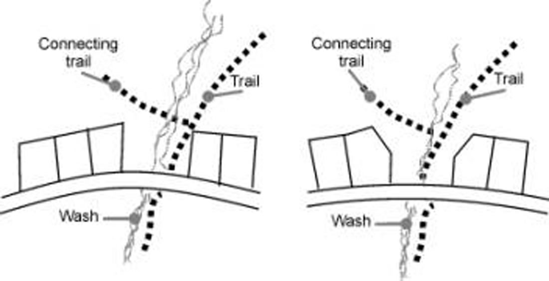
Acute angles
Rationale: The angles will produce a gradual narrowing from the adjacent open space leading into the corridors. This will better blend development with the environment, minimize sudden constrictions, and provide better views.
3.10.3. Along undisturbed open space, where a building envelope is not used, not more than fifty percent of the homes shall have a building height greater than one story or twenty four feet measured to top of the parapet or the top of the ridge on sloping roofs. Where building envelopes are used, there is no restriction on the number of homes greater than one story, except regardless of lot grading, no more than two homes above one-story, or twenty-four feet may be adjacent to one another. (R)
Rationale: For view preservation and to blend into the desert environment, buildings must maintain a low single-story profile to be in character with adjacent Sonoran Desert vegetation which generally reaches a mature height of approximately twenty two to twenty five feet. By maintaining a lower building height the sense of open space will be enhanced.
Single-Story Homes Blend With Low Profile Desert Vegetation Better Than Two-Story Units
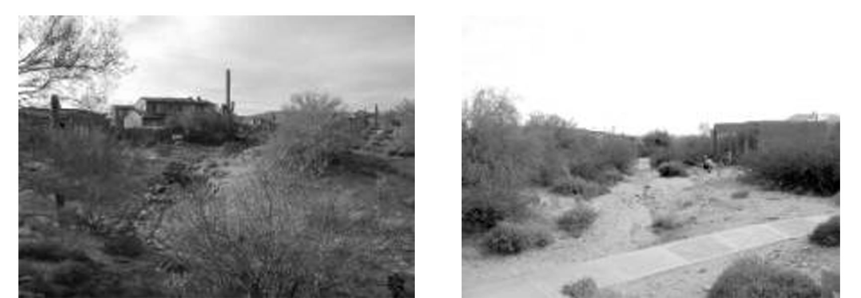
Single-story homes
3.11. Single family—Low Density Residential (Lots Of Eighteen Thousand Square Feet or More).
3.11.1. On Non-Hillside Lots Adjacent to the Sonoran Preserve Edge, all improvements, including driveways, landscaping, and underground utilities, shall be located within a building envelope, occupying no more than fifty percent of the lot up to a maximum of twenty thousand square feet area of the lot area, whichever is less. (R)
Rationale: By establishing a building envelope, a portion of each lot is preserved and the character of the area is maintained, which creates value for all the residents.
3.11.2. The building envelopes may require greater setbacks than the minimum required by ordinance to maintain site features in an undisturbed condition, such as rock outcroppings, significant stands of vegetation, or specimen trees or saguaros. The minimum setbacks defined in this ordinance are not grounds for any increases in the size of the buildings envelope. Lots to be developed with building envelopes should be designated as preservation lots (PSV) on the site plan, final subdivision plat, or lot split. Areas outside of the building envelope are to remain permanent undisturbed open space and to be designated as such on all plans submitted to the City. (P)
Rationale: The native Sonoran Desert is the major component forming the identity of this north area and therefore is to be maintained in an undisturbed condition when advantageous.
3.11.3. Individual lot grading plans shall be submitted for review and approval by the City for lots eighteen thousand square feet and larger. Vegetation and topographical features, such as specimen plants, washes and rock outcroppings, are to be identified on the plans. (R)
Rationale: Individual grading plans showing topographical features will assist the builder and City plan reviewers in identifying key natural features on a site to be preserved.
3.12. Commercial Buildings Adjacent To Preserve.
3.12.1. Commercial uses adjacent to the Sonoran Preserve, regardless of its size, should vary the building mass by varying the setbacks of the building planes to articulate and mimic the form and treatment of the preserve edge at the particular location. (P)
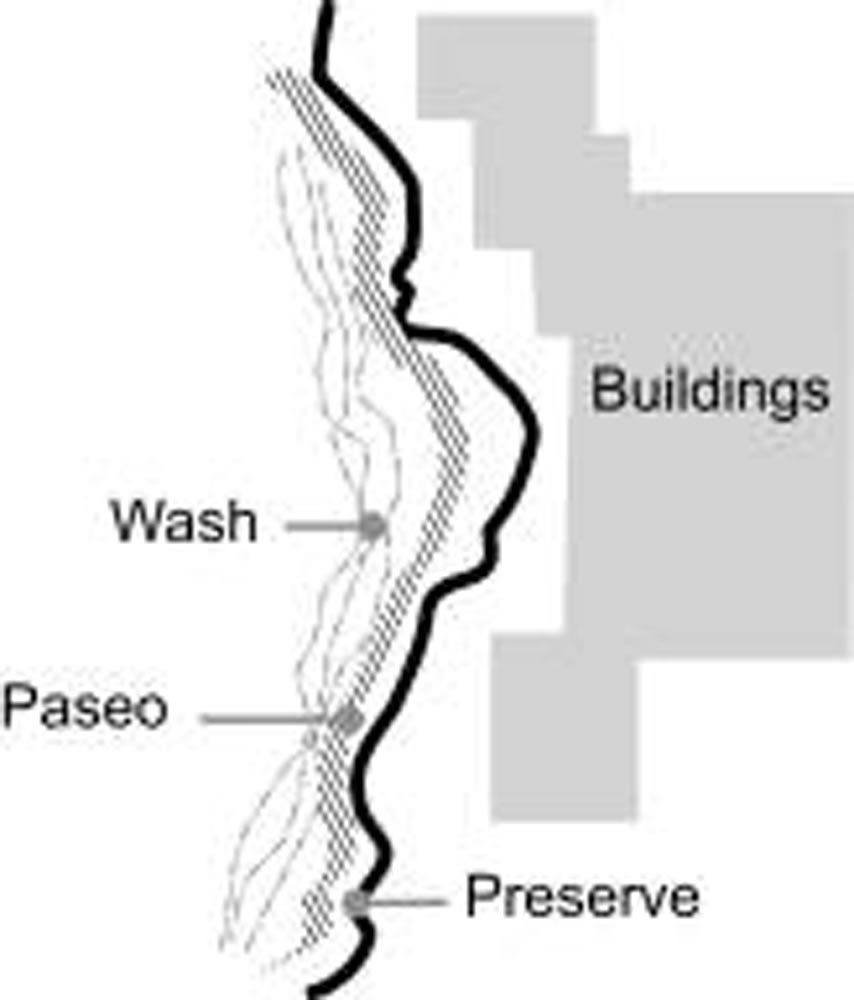
building varies with preserve edge
Rationale: Commercial uses should complement the natural edge of the Sonoran Preserve. Buildings should be massed to allow the built form to reflect the irregular natural land forms.
3.12.2. Commercial uses adjacent to the Sonoran Preserve should include public pedestrian access through the site to the public open space and connected to designated trailheads per the approved Sonoran Preserve Master Edge Plan. Design for access to the Sonoran Preserve at all locations should be approved by the City. (P)
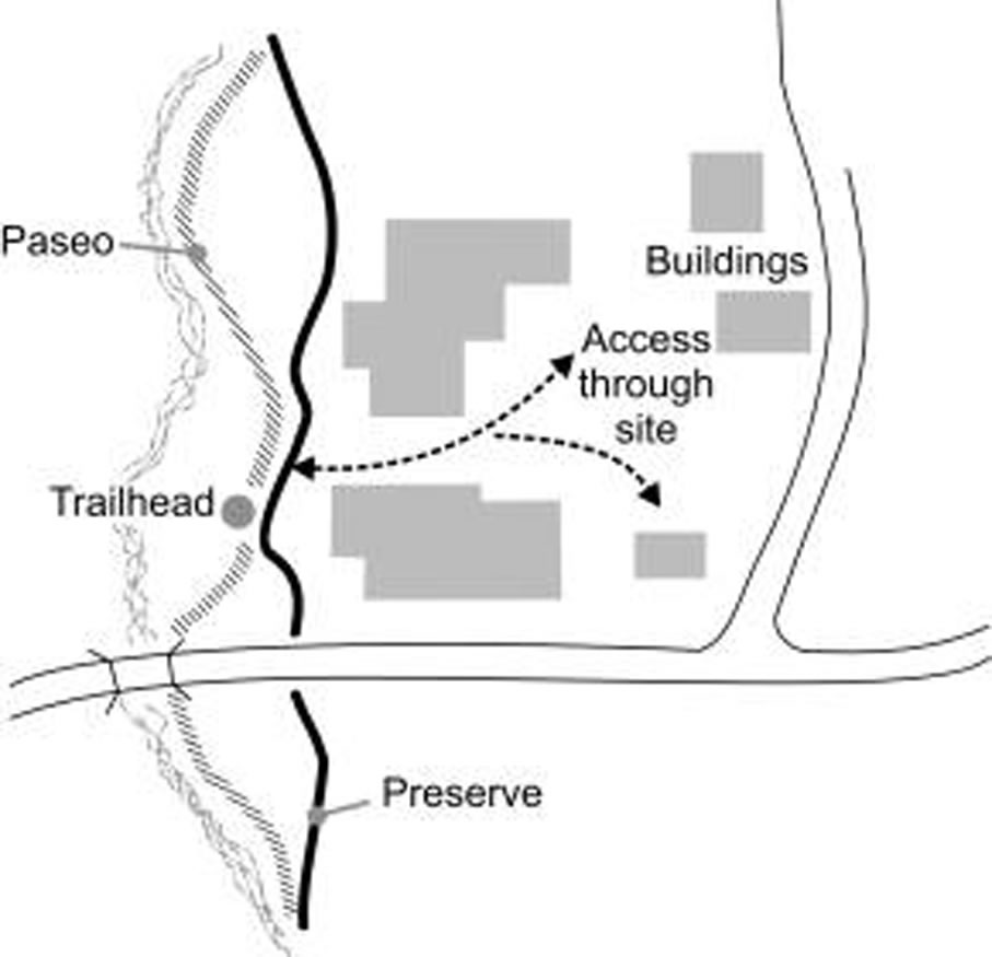
Pedestrian access through commercial site
Rationale: Access to the Sonoran Preserve must be planned at specific points through developed sites in order to prevent spider trails into the preserve area, as well as provide for control and safety at entrances to adjacent commercial development.
3.12.3. Commercial uses adjacent to the Sonoran Preserve should enhance the enjoyment and take advantage of proximity to the preserve by:
(A) Providing for outdoor uses to allow enjoyment of the Sonoran Preserve, such as restaurants with outdoor patios, employee lunch or break areas, and recreation based businesses, such as bike or roller blade rentals, located between buildings and preserve.
(B) Providing adequate open space between buildings to provide views into the Sonoran Preserve.
(C) Where parking is within seventy feet of the Sonoran Preserve Edge or paseo, design parking in small groupings of less than fifty cars, separated by pedestrian pathways of material other than asphalt, and shaded, to provide easily identifiable and accessible connections to the paseo and preserve. (P)
Rationale: Commercial uses located at the edge of the Sonoran Preserve can take advantage of proximity to preserve areas as well as provide safety through informal monitoring of such public spaces. Outdoor uses provide an amenity for employees as well as customers.
3.12.4. Service areas contiguous to Sonoran Preserve or private undisturbed open space areas are not allowed. All refuse and service areas must be separated from the preserve by parking or a circulation/service driveway and screened from views of abutting streets or the preserve with decorative walls and landscaping. (R)
Rationale: For the appropriate blending of the Sonoran Preserve with the built environment, service and refuse areas must not be visible from the preserve edge. Where service areas might be visible, the appropriate buffering and design of the loading, refuse, or service area will mitigate the effect of the service area on adjacent preserve.
3.12.5. Projects adjacent to the Sonoran Preserve Edge should provide shared or joint use of parking with other projects to facilitate accessibility to the preserve as approved by the City. (P)
Rationale: The provision of parking with easy access to the preserve will attract people that not only use the Sonoran Preserve but they can also be potential customers for commercial sites. The sharing of parking allows a more efficient use of parking in adjacent projects as parking loads distribute evenly depending on the different land uses.
3.12.6. Parking adjacent to the Sonoran preserve edge shall be limited to ten percent above the minimum required by ordinance, except:
(A) An additional five percent is allowed for a pedestrian pathway a minimum length of one hundred feet provided across the parking lot to the preserve or paseo, when the pathway is a material other than asphalt, fifty percent shaded, and on addition to required perimeter sidewalks or multi-use trails, or
(B) An additional five percent above the minimum required parking if landscaped planters are provided every fifty feet (approximately every five parking spaces). (R)
Rationale: The visual impact and heat gain from parking lots in proximity to the Sonoran Preserve should be minimized. Where parking lots are close to the preserve, it should not be unpleasant to cross the parking lot to access the preserve.
|
TYPICAL |
GENUS SPECIES |
|---|---|
|
TREES— |
|
|
CERCIDIUM FLORIDUM |
BLUE PALO VERDE |
|
CERCIDIUM MICROPHYLLUM |
FOOTHILL PALO VERDE |
|
CHILOPSIS LINEARIS |
DESERT WILLOW |
|
OLNEYA TESOTA |
IRONWOOD |
|
PROSOPIS VELUTINA |
NATIVE MESQUITE |
|
SHRUBS— |
|
|
ACACIA GREGGII |
CAT CLAW ACACIA |
|
AMBROSIA AMBROSOIDES |
CANYON RAGWEED |
|
AMBROSIA DELTOIDEA |
TRIANGLE LEAF BUR SAGE |
|
ASCLEPIAS SUBULATA |
DESERT MILKWEED |
|
ATRIPLEX CANESCENS |
FOURWING SALTBUSH |
|
BACCHARIS SAROTHROIDES |
DESERT BROOM (MALE CULTIVARS) |
|
CALLIANDRA ERIOPHYLLA |
FAIRY DUSTER |
|
CANOTIA HOLACANTHA |
CRUCIFIXION THORN |
|
CELTIS PALLIDA |
DESERT HACKBERRY |
|
ENCELIA FARINOSA |
BRITTLEBRUSH |
|
EPHEDRA ASPERA |
|
|
ERICAMERIA TRIFURCA |
MORMON TEA |
|
ERICAMERIA LARICIFOLIA |
TURPENTINE BUSH |
|
ERIOGONUM FASCICULATUM |
FLATTOP BUCKWHEAT |
|
FOUQUIERIA SPLENDENS |
OCOTILLO |
|
HYPTIS EMORYI |
DESERT LAVENDER |
|
JUSTICIA CALIFORNICA |
CHUPAROSA |
|
KRAMERIA GRAYI |
WHITE RATANY |
|
LARREA TRIDENTATA |
CRESOSOTE BUSH |
|
LYCIUM BERLANDIERI |
WOLFBERRY |
|
LYCIUM FERMONTII |
TOMATILLO |
|
PSILOTROPHE COOPERII |
PAPER FLOWER |
|
SIMMONDSIA CHINENSIS |
JOJOBA |
|
VIGUIERIA DELTOIDEA |
GOLDENEYE |
|
ZIZYPHUS OBTUSIFOLIA VAR. CANESCENS |
GREYTHORN |
|
CACTI AND SUCCULENTS— |
|
|
CARNEGIEA GIGANTEA |
SAGUARO |
|
ECHINOCEREUS FASCICULATUS |
HEDGEHOG CACTUS |
|
FEROCACTUS ACANTHODES |
COMPASS BARREL |
|
FEROCACTUS WISLIZENII |
FISHHOOK BARREL |
|
MAMMILLARIA MICROCARPA |
FISHHOOK PINCUSHION |
|
OPUNTIA ACANTHOCARPA |
BUCKHORN CHOLLA |
|
OPUNTIA BIGELOVII |
TEDDY BEAR CHOLLA |
|
OPUNTIA ENGELMANNII |
ENGELMANN’S PRICKLY PEAR |
|
OPUNTIA FULGIDA |
CHAIN FRUIT CHOLLA |
|
OPUNTIA LEPTOCAULIS |
DESERT CHRISTMAS CHOLLA |
|
ANNUAL WILDFLOWERS— |
|
|
ARGEMONE PLEIACANTHA |
PRICKLY POPPY |
|
ESCHSCHOLTZIA MEXICANA |
MEXICAN GOLD POPPY |
|
KALLSTROEMIA GRANDIFLORA |
ARIZONA POPPY |
|
LUPINUS ARIZONICUS |
ARIZONA LUPINE |
|
LUPINUS SPARSIFLORUS |
DESERT LUPINE |
|
ORTHOCARPUS PURPURACENS |
OWL’S CLOVER |
|
PECTIS PAPPOSA |
CHINCH WEED |
|
PLANTAGO INSULARIS |
INDIAN WHEAT |
|
SALVIA COLUMBARIAE |
CHIA |
|
PERENNIAL WILDFLOWERS— |
|
|
ARGEMONE PLATYCERAS |
PRICKLY POPPY |
|
BAILEYA MULTIRADIATA |
DESERT MARIGOLD |
|
DICHELOSTEMMA PULCHELLUM |
BLUEDICKS |
|
DYSSODIA PENTACHAETA |
DYSSODIA |
|
ERIGERON DIVERGENS |
SPREADING FLEABANE |
|
PENSTEMON PARRYII |
PARRY’S PENSTEMON |
|
SENNA COVESII (CASSIA) |
DESERT SENNA |
|
GRASSES— |
|
|
ARISTIDA PURPUREA |
PURPLE THREE-AWN |
|
HILARIA RIGIDA |
BIG GALETA |
|
TRICHACHINE CALIFORNICA |
COTTON-TOP |
|
THERE ARE PUBLIC AREAS WHERE IT MAY NOT BE AS CRITICAL THAT PLANT MATERIALS USED ARE NATIVE TO THE SONORAN DESERT BUT IT IS IMPORTANT THAT PLANT MATERIALS REPRESENT PLANTS THAT ARE GENERALLY NATIVE TO THE SOUTHWEST DESERTS OR HAVE THE APPEARANCE OF BEING NATIVE TO THOSE DESERTS. THE FOLLOWING PLANT LIST IS AN EXPANSION OF THE ABOVE LIST AND INCLUDES SONORAN DESERT NATIVES AS WELL AS NON-NATIVES THAT ARE REPRESENTATIVE OF SOUTHWEST DESERTS. THIS PLANT LIST IS TO BE USED FOR PUBLIC AREAS. |
|
|
TREES—IN ADDITION TO THOSE IDENTIFIED ABOVE. |
|
|
ACACIA BERLANDIERI |
GUAJILLO ACACIA |
|
ACACIA FARNESIANA |
SWEET ACACIA |
|
ACACIA OCCIDENTALIS |
SONORAN CATCLAW ACACIA |
|
ACACIA SCHAFFNERI |
TWISTED ACACIA |
|
ACACIA STENOPHYLLA |
SHOESTRING ACACIA |
|
ACACIA WILLARDIANA |
PALO BLANCO |
|
BAUHINIA CONGESTA |
ANACACHO ORCHID TREE |
|
CAESALPINIA CACALACO |
CASCALOTE |
|
CERCIDIUM HYBRID |
DESERT MUSEUM PALO VERDE |
|
CERCIDIUM PRAECOX |
PALO BREA |
|
LEUCAENA RETUSA |
GOLDEN BALL LEAD TREE |
|
LYSILOMA MICROPHYLLA VAR. THORNBERI |
DESERT FERN |
|
PITHECELLOBIUM FLEXICAULE |
TEXAS EBONY |
|
PITHECELLOBIUM MEXICANUM |
PALO CHINO/MEXICAN EBONY |
|
PITHECELLOBIUM PALLENS |
TENAZA |
|
PROSOPIS GLANDULOSA |
HONEY MESQUITE |
|
PROSOPIS PUBESCENS |
SCREWBEAN MESQUITE |
|
PROSOPIS TORREYANA |
TEXAS MESQUITE |
|
SOPHORA SECUNDIFLORA |
MESCAL BEAN |
|
UNGNADIA SPECIOSA |
MEXICAN-BUCKEYE |
|
ACACIA SALICINA |
WILLOW ACACIA |
|
SHRUBS—IN ADDITION TO THOSE IDENTIFIED ABOVE. |
|
|
ACACIA CONSTRICTA |
WHITE THORN ACACIA |
|
ALOYSIA GRATISSIMA |
BEE BUSH |
|
ALOYSIA LYCIODES |
BEE BUSH |
|
ALOYSIA MACROSTACHYA |
SWEET-STEM |
|
ANISACANTHUS ANDERSONII |
ANDERSON’S HONEYSUCKLE |
|
ANISACANTHUS QUADRIFIDUS |
FLAME HONEYSUCKLE |
|
ANISCANTHUS THURBERI |
DESERT HONEYSUCKLE |
|
ARTEMESIA LUDOVICIANA |
WHITE SAGE |
|
ATRIPLEX HYMENELYTRA |
DESERT HOLLY |
|
ATRIPLEX NUMMULARIA |
OLD MAN SALTBUSH |
|
BERBERIS HAEMATOCARPA |
RED BARBERRY |
|
BUDDLEIA MARRUBIFOLIA |
WOOLY BUTTERFLY BUSH |
|
CAESALPINIA GILLIESII |
DESERT BIRD OF PARADISE |
|
CALLIANDRA CALIFORNICA |
BAJA RED FAIRY DUSTER |
|
CALLINDRA PENINSULARIS |
BAJA RED FAIRY DUSTER |
|
CANOTIA HOLACANTHA |
CRUCIFIXION THORN |
|
CASSIA BIFLORA |
TWIN FLOWER CASSIA |
|
CASSIA WISLIZENII |
SHRUBBY CASSIA |
|
CORDIA BOISSIERI |
ANACAHUITA |
|
CORDIA PARVIFOLIA |
LITTLE LEAF CORDIA |
|
DALEA BICOLOR VAR. ARGYRAEA |
SILVER DALEA |
|
DALEA FRUTESCENS |
BLACK DALEA |
|
DALEA PULCHRA |
INDIGO BUSH |
|
DALEA VERSICOLOR VAR. SESSILIS |
WISLIZENUS DALEA |
|
DODONAEA VISCOSA |
HOPBUSH |
|
ERYTHRINA FLABELLIFORMIS |
SOUTHWEST CORALBEAN |
|
EUPHORBIA ANTHISYPHILITICA |
CANDELILLA |
|
GUTIERREZIA MICROCEPHALA |
SNAKEWEED |
|
JUSTICIA CANDICANS |
RED JUSTICIA |
|
JUSTICIA SONORAE |
PALM CANYON JUSTICIA |
|
JUSTICIA SPICIGERA |
MEXICAN HONEYSUCKLE |
|
KRAMERIA PARVIFOLIA |
RATANY |
|
LEUCOPHYLLUM CANDIDUM |
SILVER SAGE |
|
LEUCOPHYLLUM FRUTESCENS |
TEXAS SAGE |
|
LEUCOPHYLLUM LAEVIGATUM |
CHIHUAHUAN SAGE |
|
LEUCOPHYLLUM LANGMANIAE |
SIERRA MADRE SAGE |
|
LEUCOPHYLLUM PRUINOSUM |
FRAGRANT SAGE |
|
LEUCOPHYLLUM REVOLUTUM |
BLUE RANGER |
|
LEUCOPHYLLUM ZYGOPHYLLUM |
|
|
LOTUS RIGIDUS |
DESERT ROCK PEA |
|
MIMOSA BIUNCIFERA |
WAIT-A-MINUTE BUSH |
|
MIMOSA DYSOCARPA |
VELVET POD MIMOSA |
|
RHUS MICROPHYLLA |
DESERT SUMAC |
|
RHUS OVATA |
SUGARBUSH |
|
RHUS TRILOBATA |
SKUNKBUSH |
|
RUELLIA BRITTONIANA |
BRITTON’S RUELLIA |
|
RUELLIA CALIFORNICA |
RUELLIA |
|
RUELLIA PENINSULARIS |
RUELLIA |
|
SALVIA CHAMAEDRYOIDES |
BLUE SAGE |
|
SALVIA CLEVELANDII |
CHAPPARAL SAGE |
|
SALVIA GREGGII |
AUTUMN SAGE |
|
SALVIA LEUCOPHYLLA |
MEXICAN BUSH SAGE |
|
SALVIA DORRII |
DESERT SAGE |
|
TECOMA STANS |
YELLOWBELLS |
|
TRIXIS CALIFORNICA |
TRIXIS |
|
UNGNADIA SPECIOSA |
MEXICAN BUCKEYE |
|
VAUQUELINIA CORYMBOSA |
NARROW-LEAF ROSEWOOD |
|
VAUQUELINIA CALIFORNICA |
ARIZONA ROSEWOOD |
|
GROUNDCOVERS— |
|
|
ATRIPLEX SEMIBACCATA |
SALTBUSH |
|
BACCHARIS CV. |
|
|
"CENTENNIAL" |
CENTENNIAL BACCHARIS |
|
DALEA GREGGII |
INDIGO BUSH |
|
OENOTHERA BERLANDIERI |
MEXICAN EVENING PRIMROSE |
|
OENOTHERA CAESPITOSA |
TRAILING EVENING PRIMROSE |
|
OENOTHERA STUBBEI |
SALTILLO PRIMROSE |
|
VERBENA BIPINNATIFIDA |
VERBENA |
|
VERBENA GOODINGII |
GOODING’S VERBENA |
|
VERBENA TENERA |
MOSS VERBENA |
|
CACTI AND SUCCULENTS—IN ADDITION TO THOSE IDENTIFIED ABOVE. THIS IS A SAMPLE LIST OF CACTI AND SUCCULENTS THAT MAY BE APPROPRIATE FOR THE AREA. OTHER MAY BE APPROPRIATE BASED ON SIMILARITY OF HEIGHT, CONTEXT, TEXTURE, AND COLOR AS WELL AS SUITABILITY TO THE NATURAL ENVIRONMENT. |
|
|
AGAVE SPP. - SAMPLE LISTING |
|
|
AGAVE COLORATA |
MESCAL CENIZA |
|
AGAVE PARRYI |
PARRY’S AGAVE |
|
AGAVE VICTORAE-REGINAE |
ROYAL AGAVE |
|
AGAVE VILMORINIANA |
OCTOPUS AGAVE |
|
AGAVE MURPHEYI |
MURPHY’S AGAVE |
|
ALOE SPP. - SAMPLE LISTING |
|
|
ALOE BARBADENSIS |
MEDICINAL ALOE |
|
ALOE FEROX |
TREE ALOE |
|
ALOE SAPONARIA |
TIGER ALOE |
|
ALOE MARLOTHII |
TREE ALOE |
|
ALOE STRIATA |
CORAL ALOE |
|
CACTACEAE - SAMPLE LISTING |
|
|
ECHINOCACTUS GRUSONII |
GOLDEN BARREL |
|
LOPHOCEREUS SCHOTTII |
SENITA |
|
OPUNTIA BASILARIS |
BEAVERTAIL PRICKLY PEAR |
|
OPUNTIA VIOLACEA |
PURPLE PRICKLY PEAR |
|
PACHYCEREUS MARGINATUS |
MEXICAN ORGAN PIPE |
|
STENOCEREUS THURBERI |
ARIZONA ORGAN PIPE |
|
DASYLIRION ACROTRICHE |
GREEN DESERT SPOON |
|
DASYLIRION ACROTRICHE |
SOTOL, DESERT SPOON |
|
HESPERALOE FUNIFERA |
|
|
HESPERALOE PARVIFLORA |
RED HESPERALOE |
|
NOLINA MATAEPENSIS |
TREE BEAR GRASS |
|
NOLINA MICROCARPA |
BEAR GRASS |
|
YUCCA BREVIFOLIA |
JOSHUA TREE |
|
YUCCA RIGIDA |
BLUE YUCCA |
|
YUCCA ROSTRATA |
BEAKED YUCCA |
|
ANNUAL WILDFLOWERS—IN ADDITION TO THOSE IDENTIFIED ABOVE |
|
|
GAILLARDIA PULCHELLA |
FIREWHEEL |
|
LAYIA PLATYGLOSSA |
TIDY TIPS |
|
LESQUERELLA GORDONII |
YELLOW BLANKET |
|
PHACELIA CAMPAULARIA |
CALIFORNIA BLUE BELL |
|
PERENNIAL WILDFLOWERS—IN ADDITION TO THOSE IDENTIFIED ABOVE |
|
|
ALLIONIA INCARNATA |
TRAILING WINDMILLS |
|
DELPHINIUM AMABILE |
LARKSPUR |
|
MELAMPODIUM LEUCANTHUM |
BLACKFOOT DAISY |
|
PENSTEMON BACCHARIFOLIUS |
ROCK PENSTEMON |
|
PENSTEMON BARBATUS |
SCARLET PENSTEMON |
|
PENSTEMON EATONII |
FIRECRACKER PENSTEMON |
|
PENSTEMON PALMERI |
PALMER’S PENSTEMON |
|
PENSTEMON SPECTABILIS |
ROYAL PENSTEMON |
|
PENSTEMON SUPERBUS |
SUPERB PENSTEM |
|
RATIBIDA COLUMNARIS |
MEXICAN HAT, CONEFLOWER |
|
SPHAERALCEA AMBIGUA |
GLOBE-MALLOW |
|
TAGETES LEMONNII |
MOUNT LEMMON MARIGOLD |
|
ZINNIA ACEROSA |
DESERT ZINNIA |
|
ZINNIA GRANDIFLORA |
ROCKY MOUNTAIN ZINNIA |
|
GRASSES—IN ADDITION TO THOSE IDENTIFIED IN ABOVE |
|
|
MUHLENBERGIA DUMOSA |
GIANT MUHLY |
|
MUHLENBERGIA PORTERI |
BUSH MUHLY |
|
MUHLENBERGIA RIGENS |
DEER GRASS |
|
VINES— |
|
|
ANTIGONON LEPTOPUS |
CORAL VINE |
|
CALLAEUM MACROPTERA |
YELLOW ORCHID VINE |
|
CLEMATIS DRUMMONDI |
VIRGIN’S BOWER |
|
MAURANDYA ANTIRRHINIFLORA |
SNAPDRAGON VINE |
|
MERREMIA AUREA |
YELLOW MORNING GLORY VINE |
|
TYPICAL |
GENUS SPECIES |
|---|---|
|
BRACHYCHITON POPLNEUS |
BOTTLETREE |
|
CENCHRUS CILIARIS OR PENNISETUM CILIARE |
BUFFEL GRASS |
|
CYNODON DACTYLON |
COMMON BERMUDA GRASS |
|
ERAGROSTIS LEHMANNIANA |
LEHMANN’S LOVEGRASS |
|
EUCLAYPTUS SP. |
EUCALYPTUS |
|
GUTIERREZIA SAROTHRAE |
SNAKEWEED |
|
HORDEUM JUBATUM |
FOXTAIL BARLEY |
|
WASHINGTONIA SP. |
FAN PALM |
|
PENNISETUM SP. |
FOUNTAIN GRASS |
|
OLEANDER SP. |
OLEANDERS-EXCEPT FOR PETITE VARIETIES |
|
THEVETIA PERUVIANA |
YELLOW OLEANDER |
|
OLEA SP. |
OLIVE TREES |
|
PARKINSONIA ACULEATA |
JERSUALEM THORN/MEXICAN PALO VERDE |
|
PINUS SP. |
PINES |
|
PROSOPIS CHILENSIS |
CHILEAN MESQUITE-IN PARKING AREAS |
|
RHUS LANCEA |
AFRICAN SUMAC |
4. Regulatory Adopted Plan Areas. The City Council has adopted several regulatory plans, which may have additional design guidelines for the specific area. Attached are maps for these regulatory plan areas.
5. Critical Infrastructure.
5.1. Fences or freestanding walls built for the protection of critical infrastructure should be designed with enhancements to blend with the surrounding environment. (P)
Rationale: Design features that blend the structure with the surrounding environment will mitigate negative impacts.
5.2. Walls should have a finished appearance. Untextured, unfinished block and reinforced, mortar-free concrete walls should be avoided. (P)
5.3. Wall lengths exceeding 50 feet should be articulated or contain substantial landscaping to break the continuous wall surface and create varying shading patterns. (P)
Rationale (5.2—5.3): Perimeter wall treatment should provide decorative elements for visual interest and contribute an enhanced image to the surrounding community. Finished wall treatments should include decorative elements, variation in wall materials, and textured or stucco surfaces compatible with primary structures. (Ord. No. G-3392, 1991; Ord. No. G-3523, 1992; Ord. No. G-3628, 1993; Ord. No. G-3676, 1993; Ord. No. G-3690, 1993; Ord. No. G-3833, 1995; Ord. No. G-3996, 1997; Ord. No. G-4041, 1997; Ord. No. G-4045, 1997; Ord. No. G-4078, 1998; Ord. No. G-4109, 1998; Ord. No. G-4188, 1999; Ord. No. G-4238, 2000; Ord. No. G-4498, 2003; Ord. No. G-4545, 2003; Ord. No. G-4611, 2004; Ord. No. G-4690, 2005; Ord. No. G-4724, 2005; Ord. No. G-4760, 2005; Ord. No. G-5243, 2008; Ord. No. G-5447, 2009; Ord. No. G-5499, 2010; Ord. No. G-5722, 2012; Ord. No. G-6278, 2017; Ord. No. G-6868, §§ 3—10, 2021; Ord. No. G-7160, § 2, 2023)